|
search place name
|
||
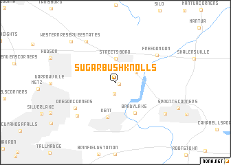
Sugar Bush Knolls (Ohio, United States - USA)Sugar Bush Knolls is a town in the Ohio region of United States - USA. An overview map of the region around Sugar Bush Knolls is displayed below.
regional and 3d topo map of Sugar Bush Knolls, United States - USA ::
Sugar Bush Knolls airports ::
The nearest airport is AKR - Akron Fulton Intl, located 21.1 km south west of Sugar Bush Knolls.
Other airports nearby include CLE - Cleveland Hopkins Intl (48.1 km north west), YNG - Youngstown Warren Rgnl (56.3 km east), PIT - Pittsburgh (pennsylva) Pittsburgh Intl (122.8 km south east), YQG - Windsor (179.1 km north west), Nearby towns ::
Twin Lakes (0.5km south east) //
Earlville (1.9km south) //
Doolittles Corners (3.0km north east) //
Streetsboro (3.9km north) //
Kent (5.7km south) //
Brady Lake (5.6km south east) //
Oregon Corners (6.5km south west) //
Freedom Dam (6.8km north east) //
Moran (7.5km north west) //
Fish Creek (7.2km south west) //
Black Horse (7.9km south east) //
Western Reserve Estates (8.6km north west) //
[all distances 'as the bird flies' and approximate] 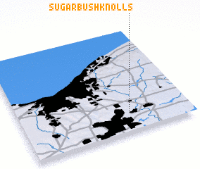 Places with similar names to Sugar Bush Knolls, United States - USA :: Disclaimer :: Information on this page comes without warranty of any kind |
||
|
Where is Sugar Bush Knolls? Elevation and coordinates ::
Latitude (lat): 41°12'16"N Longitude (lon): 81°20'46"W
Elevation (approx.): 334m (map arrows pan, magnifying glasses zoom) |
||
|
Visiting Sugar Bush Knolls? Hotel/Accommodation ::
Book a hotel in Sugar Bush Knolls Travel Guide ::
rental cars ::
car rental offers GPS waypoint ::
download a GPX waypoint (PoI) of Sugar Bush Knolls for your GPS receiver
|
||