|
search place name
|
||
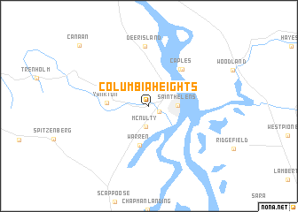
Columbia Heights (Oregon, United States - USA)Columbia Heights is a town in the Oregon region of United States - USA. An overview map of the region around Columbia Heights is displayed below.
regional and 3d topo map of Columbia Heights, United States - USA ::
Columbia Heights airports ::
The nearest airport is PDX - Portland Intl, located 35.8 km south east of Columbia Heights.
Other airports nearby include MMV - Mackminnville Mc Minnville Muni (78.0 km south), GRF - Fort Lewis Gray Aaf (136.5 km north), TCM - Tacoma Mc Chord Afb (144.3 km north), SEA - Seattle Tacoma Intl (180.8 km north), Nearby towns ::
West Saint Helens (1.1km south east) //
McNulty (2.6km south) //
Saint Helens (2.5km east) //
Columbia City (3.8km north east) //
Warren (5.0km south) //
Yankton (3.7km west) //
Caples Landing (5.4km north east) //
Caples (5.5km north east) //
Deer Island (7.5km north) //
Canaan (9.8km north west) //
[all distances 'as the bird flies' and approximate] 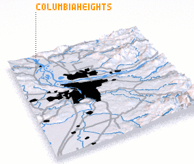 Places with similar names to Columbia Heights, United States - USA ::
// Columbia Heights (US)
// Columbia Heights (US)
// Columbia Heights (US)
// Columbia Heights (US)
// Columbia Heights (US)
// Columbia Heights (US)
// Columbia Heights (US)
// Columbia Heights (US)
// Columbia Heights (US)
Disclaimer :: Information on this page comes without warranty of any kind |
||
|
Where is Columbia Heights? Elevation and coordinates ::
Latitude (lat): 45°51'50"N Longitude (lon): 122°50'15"W
Elevation (approx.): 62m (map arrows pan, magnifying glasses zoom) |
||
|
Visiting Columbia Heights? Hotel/Accommodation ::
Book a hotel in Columbia Heights Travel Guide ::
rental cars ::
car rental offers GPS waypoint ::
download a GPX waypoint (PoI) of Columbia Heights for your GPS receiver
|
||