|
search place name
|
||
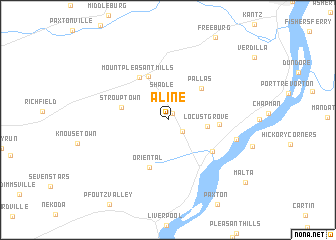
Aline (Pennsylvania, United States - USA)Aline is a town in the Pennsylvania region of United States - USA. An overview map of the region around Aline is displayed below.
regional and 3d topo map of Aline, United States - USA ::
Aline airports ::
The nearest airport is MUI - Muir Aaf, located 44.7 km south east of Aline.
Other airports nearby include MDT - Harrisburg Intl (57.3 km south), IPT - Williamsport Rgnl (62.6 km north), AOO - Altoona Blair Co (120.8 km west), APG - Aberdeen Phillips Aaf (151.8 km south east), Nearby towns ::
Troutwell (0.8km north east) //
Meiserville (1.8km south east) //
Shadle (2.8km north) //
Locust Grove (3.4km east) //
Pallas (4.5km north east) //
Mount Pleasant Mill (5.1km north) //
Strouptown (4.2km west) //
Oriental (5.5km south) //
Mount Pleasant Mills (5.3km north west) //
Hoffer (4.4km east) //
Mahantango (5.2km south east) //
McKees Half Falls (6.2km east) //
Malta (9.6km south east) //
[all distances 'as the bird flies' and approximate] 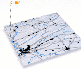 Places with similar names to Aline, United States - USA ::
Disclaimer :: Information on this page comes without warranty of any kind |
||
|
Where is Aline? Elevation and coordinates ::
Latitude (lat): 40°40'50"N Longitude (lon): 76°59'15"W
Elevation (approx.): 164m (map arrows pan, magnifying glasses zoom) |
||
|
Visiting Aline? Hotel/Accommodation ::
Book a hotel in Aline Travel Guide ::
rental cars ::
car rental offers GPS waypoint ::
download a GPX waypoint (PoI) of Aline for your GPS receiver
|
||