|
search place name
|
||
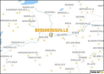
Brodheadsville (Pennsylvania, United States - USA)Brodheadsville is a town in the Pennsylvania region of United States - USA. An overview map of the region around Brodheadsville is displayed below.
regional and 3d topo map of Brodheadsville, United States - USA ::
Brodheadsville airports ::
The nearest airport is NXX - Willow Grove Nas Jrb, located 83.1 km south of Brodheadsville.
Other airports nearby include TTN - Trenton Mercer (87.1 km south east), EWR - Newark Liberty Intl (106.6 km east), TEB - Teterboro (112.7 km east), MUI - Muir Aaf (113.3 km south west), Nearby towns ::
Weir Lake (2.5km south west) //
McIlhaney (2.9km east) //
Mechanicsville (3.4km east) //
Effort (3.8km north west) //
Gilbert (3.9km west) //
Rossland (5.9km south) //
Castle Garden (6.8km south) //
Neola (5.9km north east) //
Pleasant View Lake (5.6km west) //
McMichael (7.9km north) //
Fiddletown (7.6km south west) //
Saylorsburg (6.7km south east) //
Sciota (6.6km east) //
Appenzell (8.3km north east) //
Merwinsburg (7.7km north west) //
Sun Valley (8.8km north west) //
Kunkletown (9.7km south west) //
Kingswood Estates (9.4km south west) //
[all distances 'as the bird flies' and approximate] 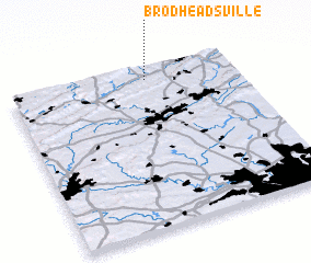 Places with similar names to Brodheadsville, United States - USA :: Disclaimer :: Information on this page comes without warranty of any kind |
||
|
Where is Brodheadsville? Elevation and coordinates ::
Latitude (lat): 40°55'28"N Longitude (lon): 75°23'39"W
Elevation (approx.): 229m (map arrows pan, magnifying glasses zoom) |
||
|
Visiting Brodheadsville? Hotel/Accommodation ::
Book a hotel in Brodheadsville Travel Guide ::
rental cars ::
car rental offers GPS waypoint ::
download a GPX waypoint (PoI) of Brodheadsville for your GPS receiver
|
||