|
search place name
|
||
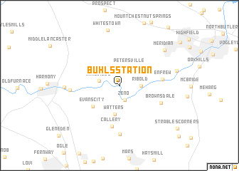
Buhls Station (Pennsylvania, United States - USA)Buhls Station is a town in the Pennsylvania region of United States - USA. An overview map of the region around Buhls Station is displayed below.
regional and 3d topo map of Buhls Station, United States - USA ::
Buhls Station airports ::
The nearest airport is PIT - Pittsburgh (pennsylva) Pittsburgh Intl, located 38.3 km south west of Buhls Station.
Other airports nearby include YNG - Youngstown Warren Rgnl (75.2 km north west), AKR - Akron Fulton Intl (124.3 km west), AOO - Altoona Blair Co (154.9 km east), CLE - Cleveland Hopkins Intl (167.7 km north west), Nearby towns ::
Zeno (2.4km south) //
Connoquenessing (2.3km north east) //
Petersville (3.1km north east) //
Wahlville (2.5km west) //
Ribold (2.5km east) //
Watters (4.5km south) //
Evans City (4.5km south west) //
Callery (6.5km south) //
Renfrew (5.2km east) //
Brownsdale (5.7km south east) //
Myoma (7.6km south) //
Eidenau (6.0km west) //
Harmony Junction (6.5km west) //
Whitestown (8.8km north) //
Meridian (7.7km north east) //
[all distances 'as the bird flies' and approximate] 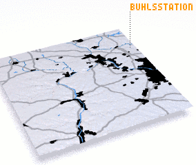 Places with similar names to Buhls Station, United States - USA ::
// Bell Station (US)
// Bull Station (US)
Disclaimer :: Information on this page comes without warranty of any kind |
||
|
Where is Buhls Station? Elevation and coordinates ::
Latitude (lat): 40°47'55"N Longitude (lon): 80°1'33"W
Elevation (approx.): 292m (map arrows pan, magnifying glasses zoom) |
||
|
Visiting Buhls Station? Hotel/Accommodation ::
Book a hotel in Buhls Station Travel Guide ::
rental cars ::
car rental offers GPS waypoint ::
download a GPX waypoint (PoI) of Buhls Station for your GPS receiver
|
||