|
search place name
|
||
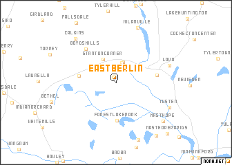
East Berlin (Pennsylvania, United States - USA)East Berlin is a town in the Pennsylvania region of United States - USA. An overview map of the region around East Berlin is displayed below.
regional and 3d topo map of East Berlin, United States - USA ::
East Berlin airports ::
The nearest airport is SWF - Newburgh Stewart Intl, located 83.3 km east of East Berlin.
Other airports nearby include TEB - Teterboro (119.7 km south east), EWR - Newark Liberty Intl (126.6 km south east), HPN - White Plains Westchester Co (130.0 km south east), LGA - New York La Guardia (136.8 km south east), Nearby towns ::
Branningville (3.3km north) //
Atco (3.4km north) //
Darbytown (3.1km north east) //
Narrowsburg (3.4km north east) //
Stanton Corner (4.1km north) //
Beach Lake (4.6km west) //
Forest Lake Park (6.1km south) //
Hunts Corner (5.0km east) //
Boyds Mills (6.6km north west) //
Lava (7.0km north east) //
Tusten (7.6km south east) //
Milanville (9.3km north) //
Calkins (8.7km north west) //
Masthope (8.4km south east) //
Westcolang Park (9.8km south east) //
Masthope Rapids (10.3km south east) //
[all distances 'as the bird flies' and approximate] 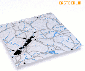 Places with similar names to East Berlin, United States - USA ::
Disclaimer :: Information on this page comes without warranty of any kind |
||
|
Where is East Berlin? Elevation and coordinates ::
Latitude (lat): 41°35'29"N Longitude (lon): 75°5'47"W
Elevation (approx.): 371m (map arrows pan, magnifying glasses zoom) |
||
|
Visiting East Berlin? Hotel/Accommodation ::
Book a hotel in East Berlin Travel Guide ::
rental cars ::
car rental offers GPS waypoint ::
download a GPX waypoint (PoI) of East Berlin for your GPS receiver
|
||