|
search place name
|
||
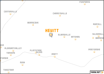
Hewitt (Pennsylvania, United States - USA)Hewitt is a town in the Pennsylvania region of United States - USA. An overview map of the region around Hewitt is displayed below.
regional and 3d topo map of Hewitt, United States - USA ::
Hewitt airports ::
The nearest airport is AOO - Altoona Blair Co, located 62.4 km north of Hewitt.
Other airports nearby include IAD - Washington Dulles Intl (128.2 km south east), EKN - Elkins Randolph Co Jennings Randolph (150.4 km south west), MDT - Harrisburg Intl (157.4 km east), DCA - Ronald Reagan Washington Natl (162.1 km south east), Nearby towns ::
Elbinsville (3.4km east) //
Pratt (7.2km south) //
Gilpin (7.4km south west) //
Beans Cove (6.8km north west) //
Flintstone (7.3km south west) //
Chaneysville (8.0km north) //
Artemas (6.6km east) //
[all distances 'as the bird flies' and approximate] 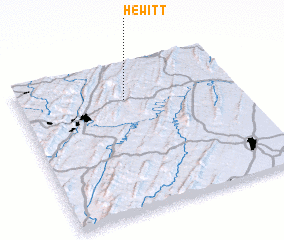 Places with similar names to Hewitt, United States - USA ::
Disclaimer :: Information on this page comes without warranty of any kind |
||
|
Where is Hewitt? Elevation and coordinates ::
Latitude (lat): 39°45'17"N Longitude (lon): 78°30'56"W
Elevation (approx.): 290m (map arrows pan, magnifying glasses zoom) |
||
|
Visiting Hewitt? Hotel/Accommodation ::
Book a hotel in Hewitt Travel Guide ::
rental cars ::
car rental offers GPS waypoint ::
download a GPX waypoint (PoI) of Hewitt for your GPS receiver
|
||