|
search place name
|
||
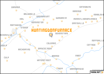
Huntingdon Furnace (Pennsylvania, United States - USA)Huntingdon Furnace is a town in the Pennsylvania region of United States - USA. An overview map of the region around Huntingdon Furnace is displayed below.
regional and 3d topo map of Huntingdon Furnace, United States - USA ::
Huntingdon Furnace airports ::
The nearest airport is AOO - Altoona Blair Co, located 43.7 km south west of Huntingdon Furnace.
Other airports nearby include IPT - Williamsport Rgnl (119.6 km north east), MDT - Harrisburg Intl (125.6 km south east), MUI - Muir Aaf (133.2 km east), IAD - Washington Dulles Intl (198.3 km south), Nearby towns ::
Franklinville (2.3km south east) //
Colerain (3.4km south) //
Seven Stars (2.7km east) //
Warriors Mark (5.3km north) //
Spruce Creek (5.6km south) //
Frogtown (6.4km north) //
Pennington (5.7km north west) //
Dungarvin (6.4km north east) //
Spring Mount (6.8km north) //
Pemberton (6.0km south west) //
Union Furnace (6.4km south west) //
Eyer (6.4km north west) //
Barree (8.0km south) //
Shoenberger (6.6km south west) //
Bald Eagle (9.4km north west) //
[all distances 'as the bird flies' and approximate]  Places with similar names to Huntingdon Furnace, United States - USA :: Disclaimer :: Information on this page comes without warranty of any kind |
||
|
Where is Huntingdon Furnace? Elevation and coordinates ::
Latitude (lat): 40°39'25"N Longitude (lon): 78°6'51"W
Elevation (approx.): 296m (map arrows pan, magnifying glasses zoom) |
||
|
Visiting Huntingdon Furnace? Hotel/Accommodation ::
Book a hotel in Huntingdon Furnace Travel Guide ::
rental cars ::
car rental offers GPS waypoint ::
download a GPX waypoint (PoI) of Huntingdon Furnace for your GPS receiver
|
||