|
search place name
|
||
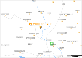
Reynoldsdale (Pennsylvania, United States - USA)Reynoldsdale is a town in the Pennsylvania region of United States - USA. An overview map of the region around Reynoldsdale is displayed below.
regional and 3d topo map of Reynoldsdale, United States - USA ::
Reynoldsdale airports ::
The nearest airport is AOO - Altoona Blair Co, located 26.1 km north east of Reynoldsdale.
Other airports nearby include PIT - Pittsburgh (pennsylva) Pittsburgh Intl (147.4 km west), MDT - Harrisburg Intl (152.9 km east), IAD - Washington Dulles Intl (163.7 km south east), MUI - Muir Aaf (172.1 km east), Nearby towns ::
Spring Meadow (2.3km north west) //
Fishertown (3.7km south west) //
Osterburg (4.0km north east) //
Saint Clairsville (4.2km east) //
Churchville (4.3km north east) //
Springhope (6.1km south west) //
Cessna (6.5km south east) //
Alum Bank (6.0km north west) //
Weyant (7.3km north) //
Imler (7.2km north east) //
Lovely (8.0km north west) //
Ryot (6.7km west) //
Point (8.6km south west) //
Belden (9.1km south east) //
[all distances 'as the bird flies' and approximate] 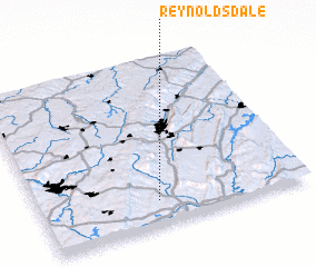 Places with similar names to Reynoldsdale, United States - USA :: Disclaimer :: Information on this page comes without warranty of any kind |
||
|
Where is Reynoldsdale? Elevation and coordinates ::
Latitude (lat): 40°8'51"N Longitude (lon): 78°33'28"W
Elevation (approx.): 336m (map arrows pan, magnifying glasses zoom) |
||
|
Visiting Reynoldsdale? Hotel/Accommodation ::
Book a hotel in Reynoldsdale Travel Guide ::
rental cars ::
car rental offers GPS waypoint ::
download a GPX waypoint (PoI) of Reynoldsdale for your GPS receiver
|
||