|
search place name
|
||
Sandy Hook (Pennsylvania, United States - USA)Sandy Hook is a town in the Pennsylvania region of United States - USA. An overview map of the region around Sandy Hook is displayed below.
regional and 3d topo map of Sandy Hook, United States - USA ::

Sandy Hook airports ::
The nearest airport is AOO - Altoona Blair Co, located 57.0 km north west of Sandy Hook.
Other airports nearby include MDT - Harrisburg Intl (89.3 km east), MUI - Muir Aaf (113.9 km north east), IAD - Washington Dulles Intl (119.9 km south), BWI - Baltimore Washington Intl (131.8 km south east), Nearby towns ::
Keefers (2.7km east) //
Edenville (4.7km south west) //
Maple Grove (4.7km north east) //
Franklin Furnace (5.5km south west) //
Freestone (5.2km north west) //
Carlton Heights (8.0km south) //
Saint Thomas (8.8km south) //
Boggstown (9.3km north) //
Fannettsburg (8.9km north west) //
Upper Strasburg (9.3km north east) //
Pleasant View (10.4km south east) //
[all distances 'as the bird flies' and approximate] 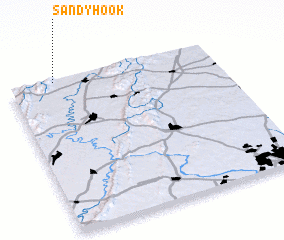 Places with similar names to Sandy Hook, United States - USA ::
// Sandy Hook (US)
// Sandy Hook (US)
// Sandheck (DE)
// Sandy Hook (US)
// Sandy Hook (US)
// Sandy Hook (US)
// Sandy Hook (US)
// Sandy Hook (US)
// Sandy Hook (US)
// Sin Dhakki (PK)
Disclaimer :: Information on this page comes without warranty of any kind |
||
|
Where is Sandy Hook? Elevation and coordinates ::
Latitude (lat): 39°59'42"N Longitude (lon): 77°46'41"W
Elevation (approx.): 240m (map arrows pan, magnifying glasses zoom) |
||
|
Visiting Sandy Hook? Hotel/Accommodation ::
Book a hotel in Sandy Hook Travel Guide ::
rental cars ::
car rental offers GPS waypoint ::
download a GPX waypoint (PoI) of Sandy Hook for your GPS receiver
|
||