|
search place name
|
||
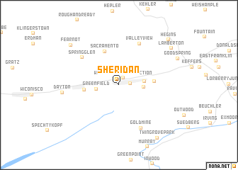
Sheridan (Pennsylvania, United States - USA)Sheridan is a town in the Pennsylvania region of United States - USA. An overview map of the region around Sheridan is displayed below.
regional and 3d topo map of Sheridan, United States - USA ::
Sheridan airports ::
The nearest airport is MUI - Muir Aaf, located 16.9 km south of Sheridan.
Other airports nearby include MDT - Harrisburg Intl (46.7 km south), IPT - Williamsport Rgnl (78.5 km north), NXX - Willow Grove Nas Jrb (128.0 km east), APG - Aberdeen Phillips Aaf (129.1 km south), Nearby towns ::
Williams Valley Junction (1.2km north east) //
Tower City (1.4km east) //
Greenfield (2.8km west) //
Orwin (3.0km east) //
Reinerton (3.1km east) //
Muir (4.2km east) //
Williamstown (4.3km west) //
Sacramento (5.5km north) //
Spring Glen (6.2km north west) //
Valley View (7.0km north) //
Gold Mine (7.3km south) //
Fearnot (8.5km north west) //
Lamberton (8.5km north east) //
Twin Grove Park (9.5km south east) //
Hegins (9.3km north east) //
[all distances 'as the bird flies' and approximate]  Places with similar names to Sheridan, United States - USA ::
Disclaimer :: Information on this page comes without warranty of any kind |
||
|
Where is Sheridan? Elevation and coordinates ::
Latitude (lat): 40°35'14"N Longitude (lon): 76°34'7"W
Elevation (approx.): 241m (map arrows pan, magnifying glasses zoom) |
||
|
Visiting Sheridan? Hotel/Accommodation ::
Book a hotel in Sheridan Travel Guide ::
rental cars ::
car rental offers GPS waypoint ::
download a GPX waypoint (PoI) of Sheridan for your GPS receiver
|
||