|
search place name
|
||
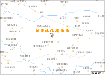
Snively Corners (Pennsylvania, United States - USA)Snively Corners is a town in the Pennsylvania region of United States - USA. An overview map of the region around Snively Corners is displayed below.
regional and 3d topo map of Snively Corners, United States - USA ::
Snively Corners airports ::
The nearest airport is YNG - Youngstown Warren Rgnl, located 88.7 km west of Snively Corners.
Other airports nearby include PIT - Pittsburgh (pennsylva) Pittsburgh Intl (98.5 km south west), AOO - Altoona Blair Co (152.3 km south east), AKR - Akron Fulton Intl (156.7 km west), BUF - Buffalo Niagara Intl (202.0 km north), Nearby towns ::
Pilgrimham (2.1km south east) //
Nineveh (2.5km north east) //
Lamartine (2.9km south west) //
Nickleville (3.9km north west) //
Mariasville (5.4km south west) //
Kossuth (5.7km north east) //
Monroe (6.4km south east) //
Turkey City (6.9km south) //
Kline (6.4km north east) //
Beaver City (6.0km south east) //
Jefferson (7.3km south east) //
Van (8.4km north) //
Alum Rock (8.9km south) //
Blairs Corners (8.5km south east) //
Wentlings Corners (8.7km south east) //
Fern (8.7km north east) //
[all distances 'as the bird flies' and approximate] 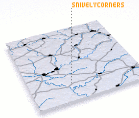 Places with similar names to Snively Corners, United States - USA :: Disclaimer :: Information on this page comes without warranty of any kind |
||
|
Where is Snively Corners? Elevation and coordinates ::
Latitude (lat): 41°14'49"N Longitude (lon): 79°37'14"W
Elevation (approx.): 447m (map arrows pan, magnifying glasses zoom) |
||
|
Visiting Snively Corners? Hotel/Accommodation ::
Book a hotel in Snively Corners Travel Guide ::
rental cars ::
car rental offers GPS waypoint ::
download a GPX waypoint (PoI) of Snively Corners for your GPS receiver
|
||