|
search place name
|
||
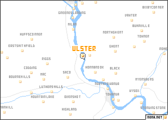
Ulster (Pennsylvania, United States - USA)Ulster is a town in the Pennsylvania region of United States - USA. An overview map of the region around Ulster is displayed below.
regional and 3d topo map of Ulster, United States - USA ::
Ulster airports ::
The nearest airport is IPT - Williamsport Rgnl, located 75.6 km south west of Ulster.
Other airports nearby include SYR - Syracuse Hancock Intl (144.3 km north), MUI - Muir Aaf (156.8 km south), ROC - Greater Rochester Intl (171.0 km north west), MDT - Harrisburg Intl (184.8 km south), Nearby towns ::
Sheshequin (1.4km north east) //
Hornbrook (3.3km south east) //
Saco (4.8km south west) //
Quarry Glen (5.5km south east) //
Ghent (5.5km east) //
Milan (7.1km north) //
Black (6.0km south east) //
Riggs (6.2km west) //
North Towanda (7.6km south east) //
North Ghent (7.1km north east) //
Luthers Mills (8.9km south west) //
Towanda (10.0km south east) //
[all distances 'as the bird flies' and approximate]  Places with similar names to Ulster, United States - USA :: Disclaimer :: Information on this page comes without warranty of any kind |
||
|
Where is Ulster? Elevation and coordinates ::
Latitude (lat): 41°50'45"N Longitude (lon): 76°30'8"W
Elevation (approx.): 232m (map arrows pan, magnifying glasses zoom) |
||
|
Visiting Ulster? Hotel/Accommodation ::
Book a hotel in Ulster Travel Guide ::
rental cars ::
car rental offers GPS waypoint ::
download a GPX waypoint (PoI) of Ulster for your GPS receiver
|
||