|
search place name
|
||
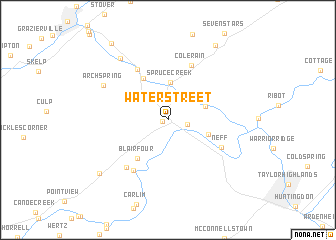
Water Street (Pennsylvania, United States - USA)Water Street is a town in the Pennsylvania region of United States - USA. An overview map of the region around Water Street is displayed below.
regional and 3d topo map of Water Street, United States - USA ::
Water Street airports ::
The nearest airport is AOO - Altoona Blair Co, located 34.2 km south west of Water Street.
Other airports nearby include MDT - Harrisburg Intl (124.1 km east), IPT - Williamsport Rgnl (126.7 km north east), MUI - Muir Aaf (133.8 km east), IAD - Washington Dulles Intl (189.9 km south), Nearby towns ::
Shaffersville (0.5km west) //
Alfarata (1.8km east) //
Spruce Creek (4.2km north) //
Barree (3.5km north east) //
Alexandria (3.8km south east) //
Union Furnace (5.1km north west) //
Blairfour (5.0km south west) //
Pemberton (6.2km north west) //
Colerain (6.4km north) //
Neff (5.5km south east) //
Mount Etna (6.4km south west) //
Etna Furnace (6.4km south west) //
Arch Spring (6.7km north west) //
Shoenberger (8.0km north west) //
Yellow Spring (8.4km south west) //
Franklinville (9.3km north east) //
Birmingham (9.8km north west) //
[all distances 'as the bird flies' and approximate] 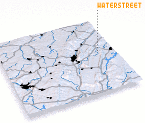 Places with similar names to Water Street, United States - USA ::
// Waterstraat (NL)
// Wetterstraat (BE)
Disclaimer :: Information on this page comes without warranty of any kind |
||
|
Where is Water Street? Elevation and coordinates ::
Latitude (lat): 40°34'17"N Longitude (lon): 78°8'18"W
Elevation (approx.): 234m (map arrows pan, magnifying glasses zoom) |
||
|
Visiting Water Street? Hotel/Accommodation ::
Book a hotel in Water Street Travel Guide ::
rental cars ::
car rental offers GPS waypoint ::
download a GPX waypoint (PoI) of Water Street for your GPS receiver
|
||