|
search place name
|
||
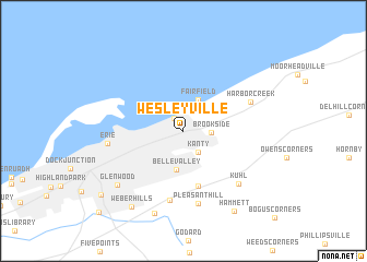
Wesleyville (Pennsylvania, United States - USA)Wesleyville is a town in the Pennsylvania region of United States - USA. An overview map of the region around Wesleyville is displayed below.
regional and 3d topo map of Wesleyville, United States - USA ::
Wesleyville airports ::
The nearest airport is YNG - Youngstown Warren Rgnl, located 112.2 km south west of Wesleyville.
Other airports nearby include YHM - Hamilton (115.0 km north), YXU - London (136.5 km north west), BUF - Buffalo Niagara Intl (137.9 km north east), IAG - Niagara Falls Intl (138.7 km north east), Nearby towns ::
Lawrence Park (1.5km north west) //
Kanty (2.4km south east) //
Brookside (2.1km east) //
Fairfield (3.3km north) //
Belle Valley (4.0km south) //
Belleview Heights (5.7km south) //
Langdon (7.1km south) //
Harborcreek (5.9km north east) //
Pleasant Hill (7.5km south) //
Kuhl (6.8km south east) //
Erie (5.9km west) //
Glenwood (7.5km south west) //
Glenmar Gardens (8.8km south) //
Weber Hills (8.7km south west) //
Hammett (9.0km south east) //
Chestnut Hill (9.1km south west) //
Kearsarge (10.5km south west) //
[all distances 'as the bird flies' and approximate]  Places with similar names to Wesleyville, United States - USA ::
Disclaimer :: Information on this page comes without warranty of any kind |
||
|
Where is Wesleyville? Elevation and coordinates ::
Latitude (lat): 42°8'25"N Longitude (lon): 80°0'55"W
Elevation (approx.): 221m (map arrows pan, magnifying glasses zoom) |
||
|
Visiting Wesleyville? Hotel/Accommodation ::
Book a hotel in Wesleyville Travel Guide ::
rental cars ::
car rental offers GPS waypoint ::
download a GPX waypoint (PoI) of Wesleyville for your GPS receiver
|
||