|
search place name
|
||
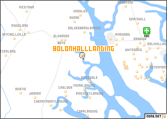
Bolon Hall Landing (South Carolina, United States - USA)Bolon Hall Landing is a town in the South Carolina region of United States - USA. An overview map of the region around Bolon Hall Landing is displayed below.
regional and 3d topo map of Bolon Hall Landing, United States - USA ::
Bolon Hall Landing airports ::
The nearest airport is NBC - Beaufort Mcas, located 13.7 km north east of Bolon Hall Landing.
Other airports nearby include SAV - Savannah Hilton Head Intl (46.2 km south west), SVN - Hunter Aaf (53.2 km south west), CHS - Charleston Afb Intl (92.8 km north east), AGS - Bush Field Augusta Rgnl At Bush Fld (148.2 km north west), Nearby towns ::
Riverdale (5.1km south) //
Boyd (5.1km north west) //
Nevadum (5.6km north west) //
Salvesbarg Landing (6.2km north) //
Old House (6.1km north west) //
Fripp Landing (6.7km south) //
Capehart Housing Project (6.8km north east) //
Laurel Bay (7.1km north east) //
Chelsea (8.0km south west) //
Irongate (7.7km north east) //
Pinckney Landing (8.7km south) //
Murad (8.7km north) //
Baileys Landing (8.8km south) //
Pinewood (8.8km north east) //
[all distances 'as the bird flies' and approximate] 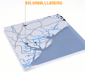 Places with similar names to Bolon Hall Landing, United States - USA :: Disclaimer :: Information on this page comes without warranty of any kind |
||
|
Where is Bolon Hall Landing? Elevation and coordinates ::
Latitude (lat): 32°25'10"N Longitude (lon): 80°51'6"W
Elevation (approx.): 14m (map arrows pan, magnifying glasses zoom) |
||
|
Visiting Bolon Hall Landing? Hotel/Accommodation ::
Book a hotel in Bolon Hall Landing Travel Guide ::
rental cars ::
car rental offers GPS waypoint ::
download a GPX waypoint (PoI) of Bolon Hall Landing for your GPS receiver
|
||