|
search place name
|
||
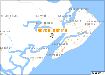
Bryan Landing (South Carolina, United States - USA)Bryan Landing is a town in the South Carolina region of United States - USA. An overview map of the region around Bryan Landing is displayed below.
regional and 3d topo map of Bryan Landing, United States - USA ::
Bryan Landing airports ::
The nearest airport is NBC - Beaufort Mcas, located 34.8 km north of Bryan Landing.
Other airports nearby include SVN - Hunter Aaf (35.4 km south west), SAV - Savannah Hilton Head Intl (36.0 km west), CHS - Charleston Afb Intl (108.9 km north east), AGS - Bush Field Augusta Rgnl At Bush Fld (170.1 km north west), Nearby towns ::
Calibogue Cay (3.9km south east) //
Point Comfort Woods (4.0km east) //
Harbour Town (4.6km south) //
Point Comfort (4.3km east) //
Brighton Beach (4.9km north west) //
Spanish Wells (4.7km east) //
Lawton (5.0km south east) //
Fairway Oaks (5.2km south east) //
Bay Pines (4.7km east) //
Heritage Woods (5.6km south) //
Opossum Point Landing (4.9km east) //
Sea Pines (5.5km south east) //
Myrtle Island (5.5km north west) //
Greenwood Forest (5.9km south east) //
Buckingham Landing (6.5km north) //
Cooper River Landing (6.3km south west) //
Wexford Plantation (5.8km east) //
Windmill Harbor (6.3km north east) //
South Sea Pines (7.2km south) //
South Beach Villas (7.2km south) //
Sea Pines Plantation (6.8km south east) //
Palmetto Bluff (6.6km north west) //
Bluffton (7.5km north west) //
Sea Pines Circle (6.7km east) //
Horse Landing (8.0km north east) //
Long Cove Plantation (7.5km east) //
Shipyard Plantation (7.7km east) //
Hickory Bluff (8.2km north east) //
Hilton Head Island (8.1km north east) //
[all distances 'as the bird flies' and approximate] 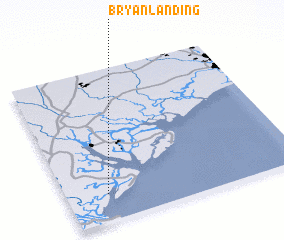 Places with similar names to Bryan Landing, United States - USA :: Disclaimer :: Information on this page comes without warranty of any kind |
||
|
Where is Bryan Landing? Elevation and coordinates ::
Latitude (lat): 32°10'34"N Longitude (lon): 80°49'30"W
Elevation (approx.): 19m (map arrows pan, magnifying glasses zoom) |
||
|
Visiting Bryan Landing? Hotel/Accommodation ::
Book a hotel in Bryan Landing Travel Guide ::
rental cars ::
car rental offers GPS waypoint ::
download a GPX waypoint (PoI) of Bryan Landing for your GPS receiver
|
||