|
search place name
|
||
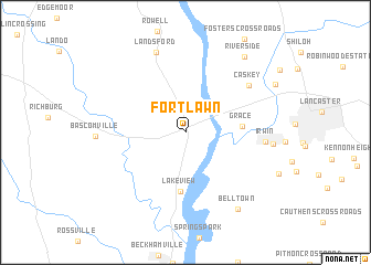
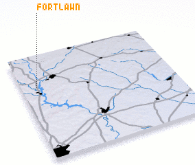
Fort Lawn (South Carolina, United States - USA)Fort Lawn is a town in the South Carolina region of United States - USA. An overview map of the region around Fort Lawn is displayed below.
regional and 3d topo map of Fort Lawn, United States - USA ::
Fort Lawn airports ::
The nearest airport is CLT - Charlotte Douglas Intl, located 57.0 km north of Fort Lawn.
Other airports nearby include CAE - Colombia Columbia Metropolitan (87.1 km south), SSC - Sumter Shaw Afb (89.8 km south east), FLO - Florence Rgnl (121.9 km south east), HKY - Hickory Rgnl (123.8 km north), Nearby towns ::
 Places with similar names to Fort Lawn, United States - USA ::
// Vertlino (RU)
// Fort Lynn (US)
// Ferteln (DE)
// Friedeln (DE)
// Friedlin (DE)
// Vartulėnai (LT)
// Fortaleny (ES)
// Verde Llano (EC)
// Frutillani (BO)
// Vrtlina (CS)
Disclaimer :: Information on this page comes without warranty of any kind |
||
|
Where is Fort Lawn? Elevation and coordinates ::
Latitude (lat): 34°42'7"N Longitude (lon): 80°53'42"W
Elevation (approx.): 164m (map arrows pan, magnifying glasses zoom) |
||
|
Visiting Fort Lawn? Hotel/Accommodation ::
Book a hotel in Fort Lawn Travel Guide ::
rental cars ::
car rental offers GPS waypoint ::
download a GPX waypoint (PoI) of Fort Lawn for your GPS receiver
|
||