|
search place name
|
||
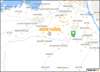
Honeywood (South Carolina, United States - USA)Honeywood is a town in the South Carolina region of United States - USA. An overview map of the region around Honeywood is displayed below.
regional and 3d topo map of Honeywood, United States - USA ::
Honeywood airports ::
The nearest airport is CAE - Colombia Columbia Metropolitan, located 7.3 km east of Honeywood.
Other airports nearby include SSC - Sumter Shaw Afb (67.4 km east), AGS - Bush Field Augusta Rgnl At Bush Fld (94.4 km south west), FLO - Florence Rgnl (139.0 km east), CLT - Charlotte Douglas Intl (144.4 km north), Nearby towns ::
Wrenwood (1.3km north) //
Walnut Creek (1.6km west) //
Land of the Lakes (2.4km north west) //
Hamlet West (2.7km north east) //
Southgate (2.7km west) //
Oakridge (2.7km south west) //
Melwood (3.0km north east) //
Cedar Estates (2.7km east) //
Regency Square (3.4km south west) //
Hillside (3.7km north east) //
Harrisburg (3.7km north west) //
Hamlet South (3.7km north east) //
Red Bank (3.7km west) //
Three Fountains (4.1km east) //
Indian Pines (4.6km north east) //
Crystal View (4.8km south east) //
Blue Ridge Terrace (5.3km south east) //
Dutchman Acres (4.9km east) //
Parkwood (5.7km north east) //
Peachtree Acres (6.4km north east) //
Cedarwood (5.7km east) //
Heritage Hills (6.7km north) //
Baskin Hills (7.1km north) //
Oakwood (6.6km north east) //
Lexington (6.7km north west) //
Oak Grove Estates (6.7km north east) //
South Congaree (6.1km east) //
Lakeview Terrace (6.8km north east) //
Coventry Woods (7.3km north) //
[all distances 'as the bird flies' and approximate] 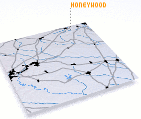 Places with similar names to Honeywood, United States - USA ::
Disclaimer :: Information on this page comes without warranty of any kind |
||
|
Where is Honeywood? Elevation and coordinates ::
Latitude (lat): 33°55'47"N Longitude (lon): 81°11'53"W
Elevation (approx.): 92m (map arrows pan, magnifying glasses zoom) |
||
|
Visiting Honeywood? Hotel/Accommodation ::
Book a hotel in Honeywood Travel Guide ::
rental cars ::
car rental offers GPS waypoint ::
download a GPX waypoint (PoI) of Honeywood for your GPS receiver
|
||