|
search place name
|
||
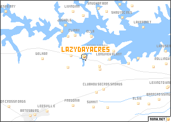
Lazy Day Acres (South Carolina, United States - USA)Lazy Day Acres is a town in the South Carolina region of United States - USA. An overview map of the region around Lazy Day Acres is displayed below.
regional and 3d topo map of Lazy Day Acres, United States - USA ::
Lazy Day Acres airports ::
The nearest airport is CAE - Colombia Columbia Metropolitan, located 30.6 km east of Lazy Day Acres.
Other airports nearby include AGS - Bush Field Augusta Rgnl At Bush Fld (86.7 km south west), SSC - Sumter Shaw Afb (89.5 km east), AND - Andersen Anderson Rgnl (128.6 km north west), CLT - Charlotte Douglas Intl (140.5 km north), Nearby towns ::
Lake Village (1.4km north west) //
Hollow Creek (2.8km south east) //
Red Star (2.9km north west) //
Oswald Park (3.1km north east) //
Priceville (3.2km south east) //
Ridge Road Crossroads (3.5km south west) //
Longview Plant (4.4km east) //
Ella (5.5km north) //
Climax (5.9km north) //
Mallard Bay (5.5km north east) //
Acapulco (6.3km north west) //
Murray (7.2km south) //
Clubhouse Crossroads (7.0km south east) //
Lake Murray Shores (7.8km north west) //
Jug Hole (8.7km north west) //
[all distances 'as the bird flies' and approximate] 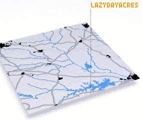 Places with similar names to Lazy Day Acres, United States - USA :: Disclaimer :: Information on this page comes without warranty of any kind |
||
|
Where is Lazy Day Acres? Elevation and coordinates ::
Latitude (lat): 34°0'56"N Longitude (lon): 81°26'17"W
Elevation (approx.): 134m (map arrows pan, magnifying glasses zoom) |
||
|
Visiting Lazy Day Acres? Hotel/Accommodation ::
Book a hotel in Lazy Day Acres Travel Guide ::
rental cars ::
car rental offers GPS waypoint ::
download a GPX waypoint (PoI) of Lazy Day Acres for your GPS receiver
|
||