|
search place name
|
||
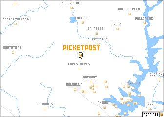
Picket Post (South Carolina, United States - USA)Picket Post is a town in the South Carolina region of United States - USA. An overview map of the region around Picket Post is displayed below.
regional and 3d topo map of Picket Post, United States - USA ::
Picket Post airports ::
The nearest airport is AND - Andersen Anderson Rgnl, located 48.4 km south east of Picket Post.
Other airports nearby include TYS - Knoxville Mc Ghee Tyson (138.8 km north west), MGE - Marietta Dobbins Arb (Atlanta Nas) (168.7 km south west), HKY - Hickory Rgnl (181.8 km north east), ATL - Hartsfield Jackson Atlanta Intl (183.4 km south west), Nearby towns ::
Forest Acres (2.4km south) //
Camp Oak (3.5km north east) //
Flat Shoals (4.5km north east) //
Oakmont (5.7km south) //
Tamassee (6.3km north east) //
Springdale (6.6km south) //
Colonial Heights (6.8km south) //
Eastcliff (6.8km south east) //
Walhalla (7.2km south) //
Burns Mill (7.2km south) //
Dutch Fork (7.6km south) //
Ebenezer (7.0km south east) //
West Union (7.7km south) //
Crystal Falls (7.9km south) //
Cheohee (8.2km north) //
Fernwood Acres (8.0km south east) //
Salem (9.5km north east) //
[all distances 'as the bird flies' and approximate]  Places with similar names to Picket Post, United States - USA :: Disclaimer :: Information on this page comes without warranty of any kind |
||
|
Where is Picket Post? Elevation and coordinates ::
Latitude (lat): 34°49'43"N Longitude (lon): 83°2'57"W
Elevation (approx.): 333m (map arrows pan, magnifying glasses zoom) |
||
|
Visiting Picket Post? Hotel/Accommodation ::
Book a hotel in Picket Post Travel Guide ::
rental cars ::
car rental offers GPS waypoint ::
download a GPX waypoint (PoI) of Picket Post for your GPS receiver
|
||