|
search place name
|
||
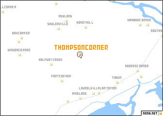
Thompson Corner (South Carolina, United States - USA)Thompson Corner is a town in the South Carolina region of United States - USA. An overview map of the region around Thompson Corner is displayed below.
regional and 3d topo map of Thompson Corner, United States - USA ::
Thompson Corner airports ::
The nearest airport is CHS - Charleston Afb Intl, located 49.5 km south west of Thompson Corner.
Other airports nearby include MYR - Myrtle Beach Intl (86.5 km north east), FLO - Florence Rgnl (118.1 km north), SSC - Sumter Shaw Afb (124.8 km north west), NBC - Beaufort Mcas (128.7 km south west), Nearby towns ::
Fort Corner (6.6km south west) //
Honey Hill (7.1km north) //
Halfway Creek (6.0km west) //
Shulerville (8.0km north west) //
Buck Hall (8.5km south) //
Laurel Hill Plantation (8.8km south east) //
Newland (9.1km north) //
Tibwin (8.9km south east) //
[all distances 'as the bird flies' and approximate] 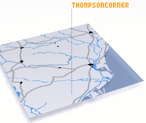 Places with similar names to Thompson Corner, United States - USA ::
// Thompson Corner (US)
// Thompson Corner (US)
// Thompson Corner (US)
// Thompson Corner (US)
// Thompson Corner (US)
// Thompson Corner (US)
Disclaimer :: Information on this page comes without warranty of any kind |
||
|
Where is Thompson Corner? Elevation and coordinates ::
Latitude (lat): 33°7'37"N Longitude (lon): 79°35'5"W
Elevation (approx.): 11m (map arrows pan, magnifying glasses zoom) |
||
|
Visiting Thompson Corner? Hotel/Accommodation ::
Book a hotel in Thompson Corner Travel Guide ::
rental cars ::
car rental offers GPS waypoint ::
download a GPX waypoint (PoI) of Thompson Corner for your GPS receiver
|
||