|
search place name
|
||
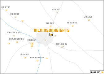
Wilkinson Heights (South Carolina, United States - USA)Wilkinson Heights is a town in the South Carolina region of United States - USA. An overview map of the region around Wilkinson Heights is displayed below.
regional and 3d topo map of Wilkinson Heights, United States - USA ::
Wilkinson Heights airports ::
The nearest airport is CAE - Colombia Columbia Metropolitan, located 55.2 km north west of Wilkinson Heights.
Other airports nearby include SSC - Sumter Shaw Afb (62.1 km north east), CHS - Charleston Afb Intl (99.7 km south east), AGS - Bush Field Augusta Rgnl At Bush Fld (106.2 km west), NBC - Beaufort Mcas (114.1 km south), Nearby towns ::
Brookdale (1.0km north east) //
Orangeburg (2.4km south west) //
Stilton (3.9km north) //
Northwood (4.7km south east) //
Lakeside Acres (4.8km south east) //
Haddock (6.3km west) //
Riverdale (6.5km south west) //
Edisto (6.7km south west) //
Rivelon (6.9km south west) //
Felder (7.9km south) //
Beverly Hills (6.9km west) //
Fersners (7.4km north east) //
Hillavista (7.5km south west) //
Jamison (9.0km north) //
Highland Park (9.6km south west) //
[all distances 'as the bird flies' and approximate] 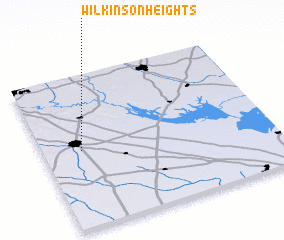 Places with similar names to Wilkinson Heights, United States - USA :: Disclaimer :: Information on this page comes without warranty of any kind |
||
|
Where is Wilkinson Heights? Elevation and coordinates ::
Latitude (lat): 33°30'7"N Longitude (lon): 80°50'0"W
Elevation (approx.): 73m (map arrows pan, magnifying glasses zoom) |
||
|
Visiting Wilkinson Heights? Hotel/Accommodation ::
Book a hotel in Wilkinson Heights Travel Guide ::
rental cars ::
car rental offers GPS waypoint ::
download a GPX waypoint (PoI) of Wilkinson Heights for your GPS receiver
|
||