|
search place name
|
||
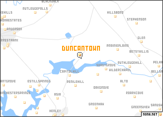
Duncantown (Tennessee, United States - USA)Duncantown is a town in the Tennessee region of United States - USA. An overview map of the region around Duncantown is displayed below.
regional and 3d topo map of Duncantown, United States - USA ::
Duncantown airports ::
The nearest airport is CHA - Chattanooga Lovell Fld, located 82.7 km south east of Duncantown.
Other airports nearby include HUA - Redstone Aaf (92.8 km south west), BNA - Nashville Intl (105.8 km north west), ANB - Anniston Metro (193.4 km south), HOP - Hopkinsville Campbell Aaf (198.6 km north west), Nearby towns ::
Calls (4.0km north east) //
Capitol Hill (4.4km south west) //
Gum Creek (4.8km south east) //
Shady Grove (5.2km south east) //
Penile Hill (6.2km south) //
Prairie Plains (7.1km east) //
Oak Grove (8.4km south east) //
Wilder Chapel (8.0km south east) //
Bruner Crossing (11.0km south west) //
[all distances 'as the bird flies' and approximate]  Places with similar names to Duncantown, United States - USA ::
// Duncan Town (BS)
// Toncontín (GT)
// Tinguindín (MX)
// Tankanton (SN)
// Toncontín (HN)
// Toncontín (HN)
// Tungan Tuni (NG)
// Toncontín (HN)
// Dong Net Niai (VN)
// Dangantan (CN)
Disclaimer :: Information on this page comes without warranty of any kind |
||
|
Where is Duncantown? Elevation and coordinates ::
Latitude (lat): 35°19'31"N Longitude (lon): 86°2'26"W
Elevation (approx.): 315m (map arrows pan, magnifying glasses zoom) |
||
|
Visiting Duncantown? Hotel/Accommodation ::
Book a hotel in Duncantown Travel Guide ::
rental cars ::
car rental offers GPS waypoint ::
download a GPX waypoint (PoI) of Duncantown for your GPS receiver
|
||