|
search place name
|
||
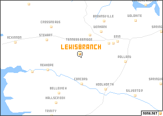
Lewis Branch (Tennessee, United States - USA)Lewis Branch is a town in the Tennessee region of United States - USA. An overview map of the region around Lewis Branch is displayed below.
regional and 3d topo map of Lewis Branch, United States - USA ::
Lewis Branch airports ::
The nearest airport is HOP - Hopkinsville Campbell Aaf, located 49.3 km north east of Lewis Branch.
Other airports nearby include BNA - Nashville Intl (99.7 km east), MKL - Jackson Mc Kellar Sipes Rgnl (128.2 km south west), HUA - Redstone Aaf (203.4 km south east), FTK - Fort Knox Godman Aaf (240.8 km north east), Nearby towns ::
Tennessee Ridge (3.2km north) //
Grays Crossing (5.5km north) //
Concord (5.9km south) //
Arlington (6.1km north east) //
Denmark (7.1km north east) //
Midway (6.8km north east) //
New Hope (6.9km south west) //
Stewart (7.7km north west) //
Woolworth (8.5km south east) //
Erin (7.7km north east) //
Belleview (9.1km south west) //
Brownsville (9.5km north east) //
Cross Roads (9.1km north west) //
[all distances 'as the bird flies' and approximate] 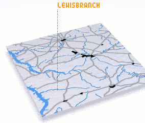 Places with similar names to Lewis Branch, United States - USA :: Disclaimer :: Information on this page comes without warranty of any kind |
||
|
Where is Lewis Branch? Elevation and coordinates ::
Latitude (lat): 36°17'0"N Longitude (lon): 87°46'10"W
Elevation (approx.): 150m (map arrows pan, magnifying glasses zoom) |
||
|
Visiting Lewis Branch? Hotel/Accommodation ::
Book a hotel in Lewis Branch Travel Guide ::
rental cars ::
car rental offers GPS waypoint ::
download a GPX waypoint (PoI) of Lewis Branch for your GPS receiver
|
||