|
search place name
|
||
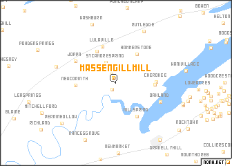
Massengill Mill (Tennessee, United States - USA)Massengill Mill is a town in the Tennessee region of United States - USA. An overview map of the region around Massengill Mill is displayed below.
regional and 3d topo map of Massengill Mill, United States - USA ::
Massengill Mill airports ::
The nearest airport is TYS - Knoxville Mc Ghee Tyson, located 59.0 km south west of Massengill Mill.
Other airports nearby include CHA - Chattanooga Lovell Fld (197.8 km south west), AND - Andersen Anderson Rgnl (204.8 km south), Nearby towns ::
Tampico (1.1km south west) //
Buffalo Springs (1.5km north west) //
Sycamore Spring (3.5km north) //
Hammer Store (5.4km north east) //
Sunset (5.7km north west) //
Lulaville (6.1km north) //
Shiloh (5.1km east) //
Mill Spring (6.1km south east) //
Cherokee (5.2km east) //
New Corinth (5.3km west) //
Joppa (6.4km north west) //
Oakland (6.6km south east) //
Rutledge (9.1km north east) //
Perrin Hollow (9.6km south west) //
[all distances 'as the bird flies' and approximate] 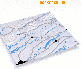 Places with similar names to Massengill Mill, United States - USA :: Disclaimer :: Information on this page comes without warranty of any kind |
||
|
Where is Massengill Mill? Elevation and coordinates ::
Latitude (lat): 36°12'20"N Longitude (lon): 83°33'22"W
Elevation (approx.): 335m (map arrows pan, magnifying glasses zoom) |
||
|
Visiting Massengill Mill? Hotel/Accommodation ::
Book a hotel in Massengill Mill Travel Guide ::
rental cars ::
car rental offers GPS waypoint ::
download a GPX waypoint (PoI) of Massengill Mill for your GPS receiver
|
||