|
search place name
|
||
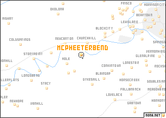
McPheeter Bend (Tennessee, United States - USA)McPheeter Bend is a town in the Tennessee region of United States - USA. An overview map of the region around McPheeter Bend is displayed below.
regional and 3d topo map of McPheeter Bend, United States - USA ::
McPheeter Bend airports ::
The nearest airport is TYS - Knoxville Mc Ghee Tyson, located 137.0 km south west of McPheeter Bend.
Other airports nearby include HKY - Hickory Rgnl (145.9 km south east), CLT - Charlotte Douglas Intl (214.2 km south east), AND - Andersen Anderson Rgnl (221.4 km south), Nearby towns ::
Goshen (3.2km south west) //
Church Hill (3.7km north) //
Mole (3.1km west) //
Blossom (4.1km south west) //
New Canton (4.8km north west) //
Dykes Mill (6.0km south) //
Blair Gap (5.8km south east) //
Conkintown (5.9km south east) //
Green Village (6.5km north east) //
Greenland (6.0km west) //
Block City (7.0km north east) //
Christian Bend (6.7km west) //
Mount Carmel (8.2km north east) //
Stacy (9.3km south west) //
West Ridge (9.5km north east) //
[all distances 'as the bird flies' and approximate] 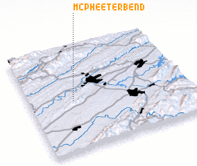 Places with similar names to McPheeter Bend, United States - USA :: Disclaimer :: Information on this page comes without warranty of any kind |
||
|
Where is McPheeter Bend? Elevation and coordinates ::
Latitude (lat): 36°29'24"N Longitude (lon): 82°43'19"W
Elevation (approx.): 383m (map arrows pan, magnifying glasses zoom) |
||
|
Visiting McPheeter Bend? Hotel/Accommodation ::
Book a hotel in McPheeter Bend Travel Guide ::
rental cars ::
car rental offers GPS waypoint ::
download a GPX waypoint (PoI) of McPheeter Bend for your GPS receiver
|
||