|
search place name
|
||
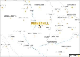
Parker Hill (Tennessee, United States - USA)Parker Hill is a town in the Tennessee region of United States - USA. An overview map of the region around Parker Hill is displayed below.
regional and 3d topo map of Parker Hill, United States - USA ::
Parker Hill airports ::
The nearest airport is BNA - Nashville Intl, located 70.2 km north west of Parker Hill.
Other airports nearby include CHA - Chattanooga Lovell Fld (110.0 km south east), HUA - Redstone Aaf (125.7 km south west), HOP - Hopkinsville Campbell Aaf (165.2 km north west), MGE - Marietta Dobbins Arb (Atlanta Nas) (245.6 km south east), Nearby towns ::
Simmons Chapel (1.9km north east) //
Burgen (3.5km north west) //
Amity (3.4km east) //
Hollow Springs (4.0km south west) //
Midway (5.9km south east) //
Mooretown (5.8km north east) //
Sheybogan (6.7km north east) //
Burt (7.8km north) //
Bradyville (7.3km north west) //
Ivy Bluff (7.7km south east) //
Red Hill (7.6km east) //
Pocahontas (8.8km south east) //
Gnat Hill (9.7km south west) //
Curlee (9.9km north west) //
Hoodoo (10.2km south west) //
Iconium (10.5km north east) //
[all distances 'as the bird flies' and approximate] 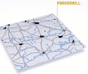 Places with similar names to Parker Hill, United States - USA ::
// Parker Hill (US)
Disclaimer :: Information on this page comes without warranty of any kind |
||
|
Where is Parker Hill? Elevation and coordinates ::
Latitude (lat): 35°42'15"N Longitude (lon): 86°5'50"W
Elevation (approx.): 382m (map arrows pan, magnifying glasses zoom) |
||
|
Visiting Parker Hill? Hotel/Accommodation ::
Book a hotel in Parker Hill Travel Guide ::
rental cars ::
car rental offers GPS waypoint ::
download a GPX waypoint (PoI) of Parker Hill for your GPS receiver
|
||