|
search place name
|
||
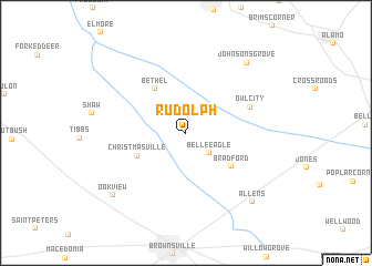
Rudolph (Tennessee, United States - USA)Rudolph is a town in the Tennessee region of United States - USA. An overview map of the region around Rudolph is displayed below.
regional and 3d topo map of Rudolph, United States - USA ::
Rudolph airports ::
The nearest airport is MKL - Jackson Mc Kellar Sipes Rgnl, located 32.4 km east of Rudolph.
Other airports nearby include NQA - Millington Rgnl Jetport (68.1 km south west), BYH - Blytheville Arkansas Intl (69.0 km north west), MEM - Memphis Intl (98.7 km south west), JBR - Jonesboro Muni (127.0 km west), Nearby towns ::
Belle Eagle (2.8km south east) //
Christmasville (4.6km south west) //
Bethel (5.1km north west) //
Bradford (5.0km south east) //
Owl City (5.9km north east) //
Johnsons Grove (8.6km north east) //
Allens (8.8km south east) //
Oakview (8.7km south west) //
[all distances 'as the bird flies' and approximate] 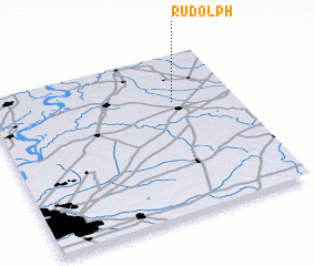 Places with similar names to Rudolph, United States - USA ::
Disclaimer :: Information on this page comes without warranty of any kind |
||
|
Where is Rudolph? Elevation and coordinates ::
Latitude (lat): 35°42'13"N Longitude (lon): 89°15'2"W
Elevation (approx.): 108m (map arrows pan, magnifying glasses zoom) |
||
|
Visiting Rudolph? Hotel/Accommodation ::
Book a hotel in Rudolph Travel Guide ::
rental cars ::
car rental offers GPS waypoint ::
download a GPX waypoint (PoI) of Rudolph for your GPS receiver
|
||