|
search place name
|
||
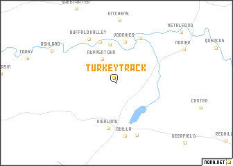
Turkey Track (Tennessee, United States - USA)Turkey Track is a town in the Tennessee region of United States - USA. An overview map of the region around Turkey Track is displayed below.
regional and 3d topo map of Turkey Track, United States - USA ::
Turkey Track airports ::
The nearest airport is HUA - Redstone Aaf, located 113.2 km south east of Turkey Track.
Other airports nearby include BNA - Nashville Intl (114.9 km north east), MKL - Jackson Mc Kellar Sipes Rgnl (124.0 km west), HOP - Hopkinsville Campbell Aaf (142.1 km north), CBM - Colombus Columbus Afb (209.5 km south west), Nearby towns ::
Ruppertown (4.2km north west) //
Providence (6.2km north) //
Voorhies (6.7km north) //
Riverside (6.9km north) //
Highland (7.4km south) //
Oak Grove (7.9km north east) //
Buffalo Valley (8.0km north west) //
Ovilla (8.6km south) //
New Haven (8.8km south) //
[all distances 'as the bird flies' and approximate]  Places with similar names to Turkey Track, United States - USA ::
// Torcotarca (BO)
// Turkey Track (US)
// Ţarāqī Tork (IR)
// Drik Drik (AU)
// Terrick Terrick (AU)
// Tragua Tragua (AR)
Disclaimer :: Information on this page comes without warranty of any kind |
||
|
Where is Turkey Track? Elevation and coordinates ::
Latitude (lat): 35°23'23"N Longitude (lon): 87°34'26"W
Elevation (approx.): 285m (map arrows pan, magnifying glasses zoom) |
||
|
Visiting Turkey Track? Hotel/Accommodation ::
Book a hotel in Turkey Track Travel Guide ::
rental cars ::
car rental offers GPS waypoint ::
download a GPX waypoint (PoI) of Turkey Track for your GPS receiver
|
||