|
search place name
|
||
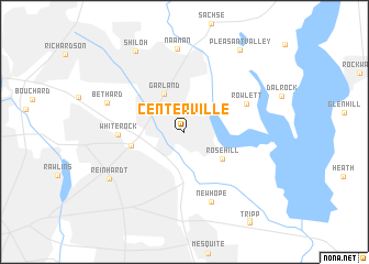
Centerville (Texas, United States - USA)Centerville is a town in the Texas region of United States - USA. An overview map of the region around Centerville is displayed below.
regional and 3d topo map of Centerville, United States - USA ::
Centerville airports ::
The nearest airport is DAL - Dallas Love Fld, located 22.0 km west of Centerville.
Other airports nearby include DFW - Dallas-fort Worth Dallas Fort Worth Intl (39.2 km west), FTW - Fort Worth Meacham Intl (69.8 km west), TYR - Tyler Pounds Rgnl (128.2 km south east), ACT - Waco Rgnl (151.7 km south), Nearby towns ::
Garland (4.3km north west) //
Rose Hill (4.2km south east) //
Zacha Junction (4.8km west) //
White Rock (5.6km west) //
Rowlett (6.0km north east) //
New Hope (7.4km south) //
Bethard (7.2km north west) //
Naaman (8.5km north) //
Reinhardt (8.0km south west) //
Shiloh (9.2km north west) //
Pleasant Valley (9.6km north east) //
[all distances 'as the bird flies' and approximate] 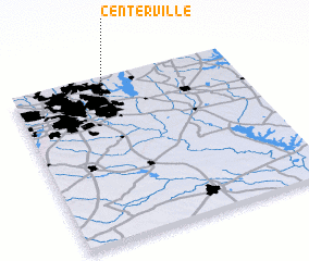 Places with similar names to Centerville, United States - USA ::
// Centerville (US)
// Centerville (US)
// Centreville (US)
// Centerville (US)
// Center Valley (US)
// Centerville (US)
// Centerville (US)
// Centerville (US)
// Centerville (US)
// Sonndörfl (AT)
Disclaimer :: Information on this page comes without warranty of any kind |
||
|
Where is Centerville? Elevation and coordinates ::
Latitude (lat): 32°52'39"N Longitude (lon): 96°37'12"W
Elevation (approx.): 170m (map arrows pan, magnifying glasses zoom) |
||
|
Visiting Centerville? Hotel/Accommodation ::
Book a hotel in Centerville Travel Guide ::
rental cars ::
car rental offers GPS waypoint ::
download a GPX waypoint (PoI) of Centerville for your GPS receiver
|
||