|
search place name
|
||
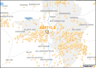
Mantyla (Utah, United States - USA)Mantyla is a town in the Utah region of United States - USA. An overview map of the region around Mantyla is displayed below.
regional and 3d topo map of Mantyla, United States - USA ::
Mantyla airports ::
The nearest airport is SLC - Salt Lake City Intl, located 14.8 km north of Mantyla.
Other airports nearby include HIF - Ogden Hill Afb (51.6 km north), Nearby towns ::
Hidden Cove Number 2 (0.4km north east) //
Brown-Tye Meadows (0.4km north east) //
Barke Circle (0.5km north west) //
Erin Meadows (0.5km north) //
Hidden Cove Number 3 (0.6km north) //
Woodhaven Village (0.5km west) //
Morningside Cove (0.7km south west) //
Robison Acres (0.8km north east) //
San Francisco Condo (1.0km south west) //
Chestnut Place Condo (1.0km south east) //
Mountain View Park Condo (1.3km north) //
Crosspointe Condo (1.2km south west) //
Woodhaven Village Number 5 (1.2km north west) //
Plymouth View (1.1km west) //
Applegate Condo (1.2km south east) //
River Meadow (1.2km north east) //
Best View (1.2km west) //
Xanadu (1.3km north east) //
Kashmir (1.5km south) //
Meadowbrook Village Condo (1.7km north) //
Taylorsville (1.4km north west) //
Paulsen Acres (1.8km south) //
Clover Hollow (1.4km east) //
Clover Hollow Condo (1.4km east) //
Meadowbrook Farms (1.8km north) //
Redwood Villa (1.5km south west) //
Barrington Park (1.9km north) //
Meadowbrook Valley (1.9km north) //
Marian Meadows (1.5km west) //
[all distances 'as the bird flies' and approximate]  Places with similar names to Mantyla, United States - USA ::
Disclaimer :: Information on this page comes without warranty of any kind |
||
|
Where is Mantyla? Elevation and coordinates ::
Latitude (lat): 40°39'40"N Longitude (lon): 111°55'27"W
Elevation (approx.): 1318m (map arrows pan, magnifying glasses zoom) |
||
|
Visiting Mantyla? Hotel/Accommodation ::
Book a hotel in Mantyla Travel Guide ::
rental cars ::
car rental offers GPS waypoint ::
download a GPX waypoint (PoI) of Mantyla for your GPS receiver
|
||