|
search place name
|
||
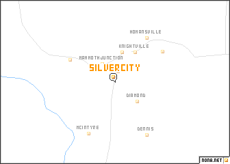
Silver City (Utah, United States - USA)Silver City is a town in the Utah region of United States - USA. An overview map of the region around Silver City is displayed below.
regional and 3d topo map of Silver City, United States - USA ::
Silver City airports ::
The nearest airport is SLC - Salt Lake City Intl, located 98.4 km north of Silver City.
Other airports nearby include HIF - Ogden Hill Afb (135.4 km north), Nearby towns ::
Mammoth (1.8km north) //
Mammoth Junction (3.4km north west) //
Tintic Junction (3.3km north west) //
Diamond (4.2km south east) //
Eureka (5.0km north) //
Knightville (5.5km north east) //
Knight (6.7km north west) //
Homansville (8.2km north east) //
Dividend (7.7km north east) //
McIntyre (9.0km south) //
Dennis (9.4km south east) //
[all distances 'as the bird flies' and approximate] 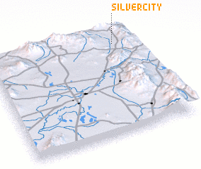 Places with similar names to Silver City, United States - USA ::
// Sulphur City (US)
// Silver City (US)
// Silverside (US)
// Silver City (US)
// Silver City (US)
// Silver City (US)
// Silver City (US)
// Silver City (US)
// Silver City (US)
// Silver City (US)
Disclaimer :: Information on this page comes without warranty of any kind |
||
|
Where is Silver City? Elevation and coordinates ::
Latitude (lat): 39°54'36"N Longitude (lon): 112°7'45"W
Elevation (approx.): 1884m (map arrows pan, magnifying glasses zoom) |
||
|
Visiting Silver City? Hotel/Accommodation ::
Book a hotel in Silver City Travel Guide ::
rental cars ::
car rental offers GPS waypoint ::
download a GPX waypoint (PoI) of Silver City for your GPS receiver
|
||