|
search place name
|
||
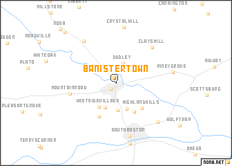
Banister Town (Virginia, United States - USA)Banister Town is a town in the Virginia region of United States - USA. An overview map of the region around Banister Town is displayed below.
regional and 3d topo map of Banister Town, United States - USA ::
Banister Town airports ::
The nearest airport is RDU - Raleigh-durham Raleigh Durham Intl, located 100.2 km south of Banister Town.
Other airports nearby include INT - Winston-salem Smith Reynolds (136.6 km south west), RIC - Richmond Intl (163.7 km north east), POB - Fayetteville Pope Afb (178.1 km south), GSB - Goldsboro Seymour Johnson Afb (181.2 km south east), Nearby towns ::
Halifax (1.2km south west) //
Dudley (3.3km north) //
Centerville (4.3km south) //
Sinai (4.2km south) //
Oak Hill Estates (4.3km south) //
Westside Village (4.4km south west) //
Fordland Estates (5.1km south east) //
Highland Hills (5.2km south east) //
Woodlawn Park (5.8km south west) //
Mountain Road (6.2km west) //
Clays Mill (7.4km north east) //
Youngers Store (8.0km north west) //
South Boston (8.6km south) //
Five Forks (8.2km south east) //
McKendree (10.6km north west) //
[all distances 'as the bird flies' and approximate] 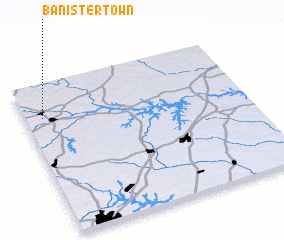 Places with similar names to Banister Town, United States - USA :: Disclaimer :: Information on this page comes without warranty of any kind |
||
|
Where is Banister Town? Elevation and coordinates ::
Latitude (lat): 36°46'27"N Longitude (lon): 78°55'14"W
Elevation (approx.): 128m (map arrows pan, magnifying glasses zoom) |
||
|
Visiting Banister Town? Hotel/Accommodation ::
Book a hotel in Banister Town Travel Guide ::
rental cars ::
car rental offers GPS waypoint ::
download a GPX waypoint (PoI) of Banister Town for your GPS receiver
|
||