|
search place name
|
||
Centerville (Virginia, United States - USA)Centerville is a town in the Virginia region of United States - USA. An overview map of the region around Centerville is displayed below.
regional and 3d topo map of Centerville, United States - USA ::

Centerville airports ::
The nearest airport is EKN - Elkins Randolph Co Jennings Randolph, located 96.1 km north west of Centerville.
Other airports nearby include IAD - Washington Dulles Intl (150.8 km north east), RIC - Richmond Intl (174.7 km south east), DCA - Ronald Reagan Washington Natl (180.7 km east), AOO - Altoona Blair Co (225.3 km north), Nearby towns ::
Bridgewater (5.5km north east) //
Stonewall (5.4km south east) //
Roman (6.3km south) //
Mount Crawford (6.0km east) //
Spring Creek (7.4km north) //
Montezuma (8.0km north) //
Burketown (7.4km south east) //
Mount Solon (7.0km west) //
Stemphleytown (9.0km north east) //
Sangerville (8.8km north west) //
Dayton (10.3km north east) //
[all distances 'as the bird flies' and approximate] 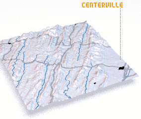 Places with similar names to Centerville, United States - USA ::
// Centerville (US)
// Centerville (US)
// Centreville (US)
// Centerville (US)
// Center Valley (US)
// Centerville (US)
// Centerville (US)
// Centerville (US)
// Centerville (US)
// Sonndörfl (AT)
Disclaimer :: Information on this page comes without warranty of any kind |
||
|
Where is Centerville? Elevation and coordinates ::
Latitude (lat): 38°20'18"N Longitude (lon): 79°0'21"W
Elevation (approx.): 418m (map arrows pan, magnifying glasses zoom) |
||
|
Visiting Centerville? Hotel/Accommodation ::
Book a hotel in Centerville Travel Guide ::
rental cars ::
car rental offers GPS waypoint ::
download a GPX waypoint (PoI) of Centerville for your GPS receiver
|
||