|
search place name
|
||
Doylesville (Virginia, United States - USA)Doylesville is a town in the Virginia region of United States - USA. An overview map of the region around Doylesville is displayed below.
regional and 3d topo map of Doylesville, United States - USA ::

Doylesville airports ::
The nearest airport is EKN - Elkins Randolph Co Jennings Randolph, located 132.2 km north west of Doylesville.
Other airports nearby include IAD - Washington Dulles Intl (137.6 km north east), RIC - Richmond Intl (138.6 km south east), DCA - Ronald Reagan Washington Natl (162.1 km north east), ADW - Camp Springs Andrews Afb (Washington Dc Naf) (173.4 km north east), Nearby towns ::
Mountfair (2.2km north) //
White Hall (3.7km south) //
Millington (5.7km south east) //
Westover Hills (6.5km south east) //
Waverly (6.3km south east) //
Thurston (7.8km south) //
Beaver Hill Mobile Home Park (8.9km south) //
Mill Ridge (7.7km south east) //
Laurel Hills (8.7km south) //
Orchard Acres (9.4km south west) //
Foothill Village (9.9km south west) //
Whipporwill Hollow (9.2km south east) //
Ivy Oaks (10.1km south east) //
[all distances 'as the bird flies' and approximate] 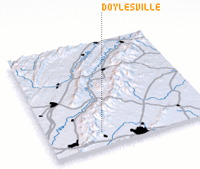 Places with similar names to Doylesville, United States - USA ::
Disclaimer :: Information on this page comes without warranty of any kind |
||
|
Where is Doylesville? Elevation and coordinates ::
Latitude (lat): 38°9'2"N Longitude (lon): 78°40'5"W
Elevation (approx.): 205m (map arrows pan, magnifying glasses zoom) |
||
|
Visiting Doylesville? Hotel/Accommodation ::
Book a hotel in Doylesville Travel Guide ::
rental cars ::
car rental offers GPS waypoint ::
download a GPX waypoint (PoI) of Doylesville for your GPS receiver
|
||