|
search place name
|
||
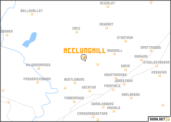
McClung Mill (Virginia, United States - USA)McClung Mill is a town in the Virginia region of United States - USA. An overview map of the region around McClung Mill is displayed below.
regional and 3d topo map of McClung Mill, United States - USA ::
McClung Mill airports ::
The nearest airport is EKN - Elkins Randolph Co Jennings Randolph, located 115.0 km north west of McClung Mill.
Other airports nearby include IAD - Washington Dulles Intl (199.3 km north east), INT - Winston-salem Smith Reynolds (214.7 km south), Nearby towns ::
Brownsburg (2.3km east) //
Bustleburg (5.2km south) //
Wades Mill (5.2km east) //
Decatur (6.6km south) //
Zack (6.6km north) //
Cedar Grove (6.9km south west) //
Mountain View (6.5km south east) //
Fairfield (7.8km south east) //
Newport (8.2km north east) //
Davis (7.2km east) //
Timber Ridge (9.1km south) //
Stony Run (8.2km north east) //
Jonestown (8.4km south east) //
[all distances 'as the bird flies' and approximate] 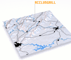 Places with similar names to McClung Mill, United States - USA :: Disclaimer :: Information on this page comes without warranty of any kind |
||
|
Where is McClung Mill? Elevation and coordinates ::
Latitude (lat): 37°56'7"N Longitude (lon): 79°20'37"W
Elevation (approx.): 398m (map arrows pan, magnifying glasses zoom) |
||
|
Visiting McClung Mill? Hotel/Accommodation ::
Book a hotel in McClung Mill Travel Guide ::
rental cars ::
car rental offers GPS waypoint ::
download a GPX waypoint (PoI) of McClung Mill for your GPS receiver
|
||