|
search place name
|
||
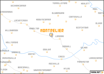
Montpelier (Virginia, United States - USA)Montpelier is a town in the Virginia region of United States - USA. An overview map of the region around Montpelier is displayed below.
regional and 3d topo map of Montpelier, United States - USA ::
Montpelier airports ::
The nearest airport is RIC - Richmond Intl, located 47.6 km south east of Montpelier.
Other airports nearby include NHK - Patuxent River Nas (123.1 km north east), IAD - Washington Dulles Intl (126.3 km north), DCA - Ronald Reagan Washington Natl (127.7 km north east), PHF - Newport News Williamsburg Intl (130.2 km south east), Nearby towns ::
Lone Oak (2.3km east) //
Jones Corner (4.9km north) //
Gouldin (5.6km south) //
Moodys Corner (6.0km north west) //
Mabelton (5.5km north west) //
Goodall (6.0km south east) //
Goshen Cross Road (6.9km north east) //
Old Bandana (8.0km north) //
Casco (8.5km south) //
Vontay (9.1km south west) //
Coatesville (9.2km north east) //
[all distances 'as the bird flies' and approximate]  Places with similar names to Montpelier, United States - USA ::
// Montpelier (US)
// Montpelier (US)
// Montpelier (US)
// Montpelier (US)
// Montpelier (US)
// Montpelier (US)
// Montpelier (US)
// Montpelier (US)
// Montpelier (US)
// Montpelier (US)
Disclaimer :: Information on this page comes without warranty of any kind |
||
|
Where is Montpelier? Elevation and coordinates ::
Latitude (lat): 37°49'16"N Longitude (lon): 77°41'5"W
Elevation (approx.): 100m (map arrows pan, magnifying glasses zoom) |
||
|
Visiting Montpelier? Hotel/Accommodation ::
Book a hotel in Montpelier Travel Guide ::
rental cars ::
car rental offers GPS waypoint ::
download a GPX waypoint (PoI) of Montpelier for your GPS receiver
|
||