|
search place name
|
||
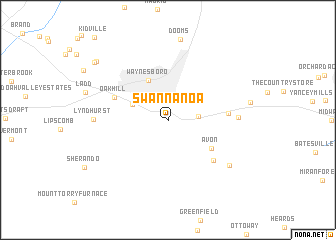
Swannanoa (Virginia, United States - USA)Swannanoa is a town in the Virginia region of United States - USA. An overview map of the region around Swannanoa is displayed below.
regional and 3d topo map of Swannanoa, United States - USA ::
Swannanoa airports ::
The nearest airport is EKN - Elkins Randolph Co Jennings Randolph, located 128.7 km north west of Swannanoa.
Other airports nearby include RIC - Richmond Intl (148.5 km south east), IAD - Washington Dulles Intl (159.9 km north east), DCA - Ronald Reagan Washington Natl (184.3 km north east), INT - Winston-salem Smith Reynolds (242.2 km south west), Nearby towns ::
Afton (2.8km east) //
Chinquapin (3.6km north west) //
Waynesboro (4.8km north) //
Avon (5.0km south east) //
Oak Hill (5.3km north west) //
Brookville Manor (5.4km east) //
Onan (6.0km south east) //
Blue Ridge Acres (6.2km east) //
Lyndhurst (6.5km west) //
Durrett Town (7.4km south east) //
Westover Hills (9.1km north west) //
Kingsbury Manor (9.1km north west) //
[all distances 'as the bird flies' and approximate] 
Disclaimer :: Information on this page comes without warranty of any kind |
||
|
Where is Swannanoa? Elevation and coordinates ::
Latitude (lat): 38°1'42"N Longitude (lon): 78°52'14"W
Elevation (approx.): 698m (map arrows pan, magnifying glasses zoom) |
||
|
Visiting Swannanoa? Hotel/Accommodation ::
Book a hotel in Swannanoa Travel Guide ::
rental cars ::
car rental offers GPS waypoint ::
download a GPX waypoint (PoI) of Swannanoa for your GPS receiver
|
||