|
search place name
|
||
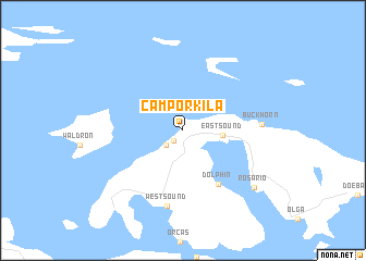
Camp Orkila (Washington, United States - USA)Camp Orkila is a town in the Washington region of United States - USA. An overview map of the region around Camp Orkila is displayed below.
regional and 3d topo map of Camp Orkila, United States - USA ::
Camp Orkila airports ::
The nearest airport is BLI - Bellingham Intl, located 31.3 km east of Camp Orkila.
Other airports nearby include YYJ - Victoria Intl (36.2 km west), YXX - Abbotsford (55.8 km north east), YVR - Vancouver Intl (57.6 km north), YCD - Nanaimo (78.6 km north west), Nearby towns ::
Beach Haven (1.2km south west) //
West Beach (1.9km south west) //
Eastsound (2.7km east) //
Dolphin (6.0km south east) //
West Sound (7.9km south) //
Buckhorn (5.4km east) //
Rosario (7.6km south east) //
[all distances 'as the bird flies' and approximate] 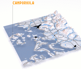 Places with similar names to Camp Orkila, United States - USA ::
// Kampirqal"a (TJ)
Disclaimer :: Information on this page comes without warranty of any kind |
||
|
Where is Camp Orkila? Elevation and coordinates ::
Latitude (lat): 48°42'5"N Longitude (lon): 122°56'26"W
Elevation (approx.): 52m (map arrows pan, magnifying glasses zoom) |
||
|
Visiting Camp Orkila? Hotel/Accommodation ::
Book a hotel in Camp Orkila Travel Guide ::
rental cars ::
car rental offers GPS waypoint ::
download a GPX waypoint (PoI) of Camp Orkila for your GPS receiver
|
||