|
search place name
|
||
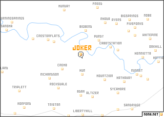
Joker (West Virginia, United States - USA)Joker is a town in the West Virginia region of United States - USA. An overview map of the region around Joker is displayed below.
regional and 3d topo map of Joker, United States - USA ::
Joker airports ::
The nearest airport is EKN - Elkins Randolph Co Jennings Randolph, located 113.9 km east of Joker.
Other airports nearby include LCK - Columbus Rickenbacker Intl (182.0 km north west), CMH - Port Columbus Intl (191.5 km north west), PIT - Pittsburgh (pennsylva) Pittsburgh Intl (193.5 km north east), Nearby towns ::
Hur (3.6km south) //
Cremo (4.2km south west) //
Purdy (5.2km north east) //
Bigbend (6.5km north) //
Cabot Station (5.7km north east) //
Mount Zion (6.3km south east) //
Annamoriah (6.3km north west) //
Grantsville (6.7km east) //
Adam (8.4km south) //
Rocksdale (8.0km south west) //
Richardson (7.3km south west) //
Creston Flats (7.4km north west) //
Altizer (8.9km south) //
Rhoda (9.2km north east) //
Ayers (10.1km north east) //
Sycamore (10.1km south east) //
[all distances 'as the bird flies' and approximate] 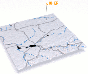 Places with similar names to Joker, United States - USA ::
Disclaimer :: Information on this page comes without warranty of any kind |
||
|
Where is Joker? Elevation and coordinates ::
Latitude (lat): 38°54'21"N Longitude (lon): 81°10'11"W
Elevation (approx.): 337m (map arrows pan, magnifying glasses zoom) |
||
|
Visiting Joker? Hotel/Accommodation ::
Book a hotel in Joker Travel Guide ::
rental cars ::
car rental offers GPS waypoint ::
download a GPX waypoint (PoI) of Joker for your GPS receiver
|
||