|
search place name
|
||
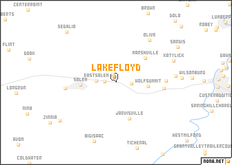
Lake Floyd (West Virginia, United States - USA)Lake Floyd is a town in the West Virginia region of United States - USA. An overview map of the region around Lake Floyd is displayed below.
regional and 3d topo map of Lake Floyd, United States - USA ::
Lake Floyd airports ::
The nearest airport is EKN - Elkins Randolph Co Jennings Randolph, located 71.5 km south east of Lake Floyd.
Other airports nearby include PIT - Pittsburgh (pennsylva) Pittsburgh Intl (135.9 km north), AKR - Akron Fulton Intl (210.9 km north), YNG - Youngstown Warren Rgnl (219.7 km north), Nearby towns ::
Flinderation (1.4km north) //
Bristol (1.4km west) //
Maken (2.0km east) //
East Salem (2.5km west) //
Wolf Summit (4.0km east) //
Salem (4.5km west) //
Marshville (5.4km north east) //
Jarvisville (6.1km south) //
Sun Valley (6.1km east) //
Reynoldsville (6.2km east) //
Industrial (6.4km west) //
Olive (8.0km north east) //
Sedalia (10.2km north west) //
[all distances 'as the bird flies' and approximate] 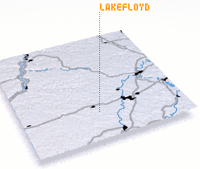 Places with similar names to Lake Floyd, United States - USA ::
// Lokfeld (DE)
// Lakefield (US)
// Lakefield (US)
// Lakefield (US)
// Lakefield (CA)
// Lakefield (US)
// Lake Field (IE)
// Le Caiflaud (FR)
Disclaimer :: Information on this page comes without warranty of any kind |
||
|
Where is Lake Floyd? Elevation and coordinates ::
Latitude (lat): 39°17'10"N Longitude (lon): 80°30'27"W
Elevation (approx.): 352m (map arrows pan, magnifying glasses zoom) |
||
|
Visiting Lake Floyd? Hotel/Accommodation ::
Book a hotel in Lake Floyd Travel Guide ::
rental cars ::
car rental offers GPS waypoint ::
download a GPX waypoint (PoI) of Lake Floyd for your GPS receiver
|
||