|
search place name
|
||
Lewisburg (West Virginia, United States - USA)Lewisburg is a town in the West Virginia region of United States - USA. An overview map of the region around Lewisburg is displayed below.
regional and 3d topo map of Lewisburg, United States - USA ::
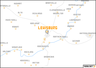
Lewisburg airports ::
The nearest airport is EKN - Elkins Randolph Co Jennings Randolph, located 131.3 km north east of Lewisburg.
Other airports nearby include INT - Winston-salem Smith Reynolds (186.2 km south), RDU - Raleigh-durham Raleigh Durham Intl (259.7 km south east), Nearby towns ::
Fair Oaks Trailer Park (2.0km south west) //
Fuller Trailer Park (2.3km south west) //
Fairlea (2.6km south west) //
Teaberry (3.5km south) //
Cedar Knoll Trailer Park (3.5km south) //
North Caldwell (4.3km south east) //
Morlunda (5.2km north west) //
Ronceverte (6.0km south) //
Caldwell (5.1km south east) //
Maxwelton (7.8km north east) //
Richlands (7.9km north west) //
Bowes (7.7km north east) //
Clendenenville (9.1km north) //
Rockland (10.0km south west) //
[all distances 'as the bird flies' and approximate] 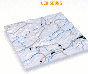 Places with similar names to Lewisburg, United States - USA ::
Disclaimer :: Information on this page comes without warranty of any kind |
||
|
Where is Lewisburg? Elevation and coordinates ::
Latitude (lat): 37°48'6"N Longitude (lon): 80°26'45"W
Elevation (approx.): 631m (map arrows pan, magnifying glasses zoom) |
||
|
Visiting Lewisburg? Hotel/Accommodation ::
Book a hotel in Lewisburg Travel Guide ::
rental cars ::
car rental offers GPS waypoint ::
download a GPX waypoint (PoI) of Lewisburg for your GPS receiver
|
||