|
search place name
|
||
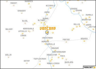
Van Camp (West Virginia, United States - USA)Van Camp is a town in the West Virginia region of United States - USA. An overview map of the region around Van Camp is displayed below.
regional and 3d topo map of Van Camp, United States - USA ::
Van Camp airports ::
The nearest airport is EKN - Elkins Randolph Co Jennings Randolph, located 193.1 km north east of Van Camp.
Other airports nearby include LCK - Columbus Rickenbacker Intl (209.9 km north west), CMH - Port Columbus Intl (227.1 km north west), INT - Winston-salem Smith Reynolds (263.6 km south east), Nearby towns ::
Lory (1.6km north east) //
Rock Creek (2.2km south) //
Harless (3.3km north) //
Hopkins (3.7km south) //
Julian (4.0km north) //
Danville (4.7km south) //
Horse Creek Junction (4.8km north) //
Adams (5.3km north) //
Altman (5.1km north west) //
Breece (4.8km west) //
Madison (6.6km south) //
Woodville (6.0km north west) //
Fork Junction (6.0km north west) //
Dodson Junction (5.8km west) //
Foster (6.3km south east) //
Morrisvale (6.2km west) //
Irene (7.8km north) //
South Madison (8.4km south east) //
Haddleton (8.8km south) //
Price Hill (9.4km south) //
[all distances 'as the bird flies' and approximate] 
Disclaimer :: Information on this page comes without warranty of any kind |
||
|
Where is Van Camp? Elevation and coordinates ::
Latitude (lat): 38°7'22"N Longitude (lon): 81°50'39"W
Elevation (approx.): 225m (map arrows pan, magnifying glasses zoom) |
||
|
Visiting Van Camp? Hotel/Accommodation ::
Book a hotel in Van Camp Travel Guide ::
rental cars ::
car rental offers GPS waypoint ::
download a GPX waypoint (PoI) of Van Camp for your GPS receiver
|
||