|
search place name
|
||
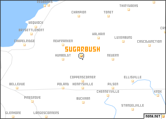
Sugar Bush (Wisconsin, United States - USA)Sugar Bush is a town in the Wisconsin region of United States - USA. An overview map of the region around Sugar Bush is displayed below.
regional and 3d topo map of Sugar Bush, United States - USA ::
Sugar Bush airports ::
The nearest airport is GRB - Green Bay Austin Straubel Intl, located 27.4 km west of Sugar Bush.
Other airports nearby include MKE - Milwaukee General Mitchell Intl (172.9 km south), MSN - Madison Dane Co Rgnl Truax Fld (196.2 km south west), Nearby towns ::
Humboldt (3.2km west) //
Coppens Corner (4.8km south) //
New Franken (4.6km north west) //
Walhain (5.5km north east) //
Henrysville (6.4km south) //
Neuern (4.8km east) //
Poland (7.2km south west) //
Pilsen (8.0km south east) //
Cherneyville (9.0km south east) //
[all distances 'as the bird flies' and approximate] 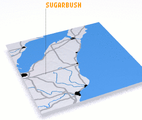 Places with similar names to Sugar Bush, United States - USA ::
// Schauerbach (DE)
// Schorbach (DE)
// Schurbach (DE)
// Sugarbush (ZA)
// Sugar Beach (US)
// Sugarbush (US)
// Schorbach (FR)
// Sugar Bush (US)
Disclaimer :: Information on this page comes without warranty of any kind |
||
|
Where is Sugar Bush? Elevation and coordinates ::
Latitude (lat): 44°30'6"N Longitude (lon): 87°47'8"W
Elevation (approx.): 260m (map arrows pan, magnifying glasses zoom) |
||
|
Visiting Sugar Bush? Hotel/Accommodation ::
Book a hotel in Sugar Bush Travel Guide ::
rental cars ::
car rental offers GPS waypoint ::
download a GPX waypoint (PoI) of Sugar Bush for your GPS receiver
|
||