|
search place name
|
||
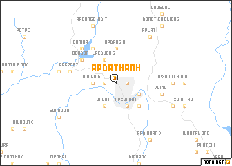
Ấp Ða Thành (Lâm Ðồng, Vietnam)Ấp Ða Thành is a town in the Lâm Ðồng region of Vietnam. An overview map of the region around Ấp Ða Thành is displayed below.
regional and 3d topo map of Ấp Ða Thành, Vietnam ::
Ấp Ða Thành airports ::
The nearest airport is NHA - Nhatrang, located 87.5 km east of Ấp Ða Thành.
Other airports nearby include SGN - Ho Chi Minh City Tansonnhat Intl (232.2 km south west), Nearby towns ::
Ấp Phước Thánh (1.9km north) //
Ấp Kim Thạch (1.8km west) //
Ấp Ða Thiên (1.8km east) //
Manline (3.6km west) //
Ấp Man Ling (4.1km north west) //
Lạc Dương (4.1km north west) //
Ðà Lạt (4.1km south west) //
Ấp Xuân An (4.1km south east) //
Khu Chi Lăng (4.1km south east) //
Ấp Ða Lợi (5.2km south east) //
Ấp Dangia (5.6km north) //
Ðan Kia (6.6km north west) //
Bondon (6.6km north west) //
Ấp Kroët (7.5km west) //
Trai Mat (7.5km east) //
Dankia (7.8km north west) //
Ấp Lat (9.2km north east) //
[all distances 'as the bird flies' and approximate] 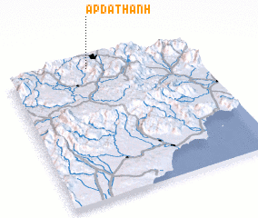 Places with similar names to Ấp Ða Thành, Vietnam ::
Disclaimer :: Information on this page comes without warranty of any kind |
||
|
Where is Ấp Ða Thành? Elevation and coordinates ::
Latitude (lat): 11°58'0"N Longitude (lon): 108°26'0"E
Elevation (approx.): 1492m (map arrows pan, magnifying glasses zoom) |
||
|
Visiting Ấp Ða Thành? Hotel/Accommodation ::
Book a hotel in Ấp Ða Thành Travel Guide ::
Buy a travel guide for Vietnam rental cars ::
car rental offers GPS waypoint ::
download a GPX waypoint (PoI) of Ấp Ða Thành for your GPS receiver
|
||