|
search place name
|
||
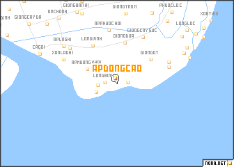
Ấp Ðòng Cao (Trà Vinh, Vietnam)Ấp Ðòng Cao is a town in the Trà Vinh region of Vietnam. An overview map of the region around Ấp Ðòng Cao is displayed below.
regional and 3d topo map of Ấp Ðòng Cao, Vietnam ::
Ấp Ðòng Cao airports ::
The nearest airport is SGN - Ho Chi Minh City Tansonnhat Intl, located 142.5 km north of Ấp Ðòng Cao.
Other airports nearby include PNH - Phnom-penh Phnom Penh Intl (281.3 km north west), Nearby towns ::
Ấp Cồn Cù (1.7km east) //
Long Bình (2.0km west) //
Ấp Long Thành (3.1km west) //
Ấp Khâu Cũ (3.5km south west) //
Ấp Mương Khai (5.2km north west) //
Giồng Ớt (6.6km north east) //
Giồng Dừa (6.7km north) //
Long Vĩnh (7.2km north west) //
Giồng Cây Sức (8.5km north east) //
Ấp Phước Hội (8.6km north) //
Giồng Bon Bon (8.6km east) //
Giồng Mù U (9.0km north east) //
Xóm La Ghi (9.2km north west) //
Ấp Thốt Lốt (9.4km north west) //
Ấp La Ghi (10.3km north west) //
[all distances 'as the bird flies' and approximate] 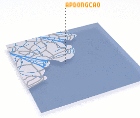 Places with similar names to Ấp Ðòng Cao, Vietnam ::
// Ấp Ðại Nga (2) (VN)
// Ấp Ðông (2) (VN)
// Ấp Ðông (2) (VN)
// Ấp Ðông Qứi (VN)
// Ấp Ðông Quì (VN)
// Ấp Tân Qứi (2) (VN)
Disclaimer :: Information on this page comes without warranty of any kind |
||
|
Where is Ấp Ðòng Cao? Elevation and coordinates ::
Latitude (lat): 9°32'56"N Longitude (lon): 106°26'4"E
Elevation (approx.): 2m (map arrows pan, magnifying glasses zoom) |
||
|
Visiting Ấp Ðòng Cao? Hotel/Accommodation ::
Book a hotel in Ấp Ðòng Cao Travel Guide ::
Buy a travel guide for Vietnam rental cars ::
car rental offers GPS waypoint ::
download a GPX waypoint (PoI) of Ấp Ðòng Cao for your GPS receiver
|
||