|
search place name
|
||
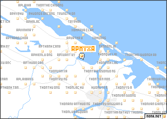
Ấp Mỹ Xá (Vietnam)Ấp Mỹ Xá is a town in Vietnam. An overview map of the region around Ấp Mỹ Xá is displayed below.
regional and 3d topo map of Ấp Mỹ Xá, Vietnam ::
Ấp Mỹ Xá airports ::
The nearest airport is DAD - Danang Intl, located 89.2 km south east of Ấp Mỹ Xá.
Other airports nearby include PKZ - Pakse (246.0 km south west), Nearby towns ::
Xóm Thủ Lễ (1.9km north) //
Thôn An Thuân (1.9km south) //
Ấp An Xuân (2.6km north east) //
Ấp Khuông Phò (2.6km north west) //
Ấp Phú Ngan (2.6km south east) //
Ấp Xuân Tùy (3.6km west) //
Ấp Ðông Lâm (3.6km west) //
Thôn Kim Ðôi (3.6km east) //
Quảng Ðiền (4.0km north west) //
Ấp Thanh Bình (4.1km north west) //
Ấp Tráng Lưc (4.1km north west) //
Ấp Uát Mâu (4.1km north west) //
Thôn Hương Cần (4.1km south west) //
Thôn Vân Quât Ðông (4.0km north east) //
Thanh Phước (4.0km south east) //
Thôn An Thanh (4.0km south east) //
Ấp Hà Dồ (5.1km north west) //
Thôn Tiên Lộc (5.1km south west) //
Thôn Dương Sơn (5.1km south west) //
Xóm Ðông (5.1km north east) //
Thôn Triều Sơn Ðông (5.1km south east) //
Lại Ân (5.1km south east) //
Thôn Mâu Tài (5.1km south east) //
Thôn Quy Lai (5.3km east) //
Ấp Lai Xá Ha (5.3km west) //
Thôn Triều Sơn Trung (5.6km south) //
Xóm Phước Lâm (5.6km north) //
Ðông Phái (5.6km north) //
Thôn An Lại (5.6km east) //
[all distances 'as the bird flies' and approximate] 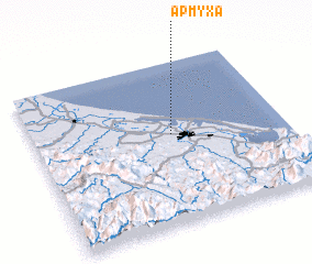 Places with similar names to Ấp Mỹ Xá, Vietnam :: Disclaimer :: Information on this page comes without warranty of any kind |
||
|
Where is Ấp Mỹ Xá? Elevation and coordinates ::
Latitude (lat): 16°33'0"N Longitude (lon): 107°33'0"E
Elevation (approx.): 2m (map arrows pan, magnifying glasses zoom) |
||
|
Visiting Ấp Mỹ Xá? Hotel/Accommodation ::
Book a hotel in Ấp Mỹ Xá Travel Guide ::
Buy a travel guide for Vietnam rental cars ::
car rental offers GPS waypoint ::
download a GPX waypoint (PoI) of Ấp Mỹ Xá for your GPS receiver
|
||