|
search place name
|
||
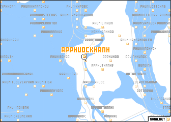
Ấp Phước Khánh (An Giang, Vietnam)Ấp Phước Khánh is a town in the An Giang region of Vietnam. An overview map of the region around Ấp Phước Khánh is displayed below.
regional and 3d topo map of Ấp Phước Khánh, Vietnam ::
Ấp Phước Khánh airports ::
The nearest airport is PNH - Phnom-penh Phnom Penh Intl, located 76.1 km north of Ấp Phước Khánh.
Other airports nearby include SGN - Ho Chi Minh City Tansonnhat Intl (171.7 km east), Nearby towns ::
Ấp Phú Hưng (0.0km north) //
Ấp Phước Hòa (1.9km south) //
Ấp Phước Thạnh (3) (1.9km south) //
Ấp Dồng Cô Ki (1.9km north) //
Bắc Nam (2.6km north east) //
Ấp Phú Lợi (2.6km north east) //
Ấp An Thạnh (4.1km north east) //
Ấp Phú Thạnh (1) (4.1km south east) //
Ấp Phú Hòa (1) (5.2km south west) //
Ấp Phú Hòa (5.5km east) //
Phumĭ Chrey Thum (5.6km north) //
An Phú (5.6km south) //
Phumĭ Băk Dai (5.5km west) //
Ấp Vĩnh Phước (5.9km south) //
Xóm Khánh Hòa (6.6km north east) //
Phumĭ Chŏng Khsăch (2) (7.4km north) //
Phumĭ Kŏpăl Kœăng (7.6km north) //
Phumĭ Li Nhŭn (8.3km north east) //
Phumĭ Prêk Da (9.2km north west) //
Phumĭ Prêk Tônléa (9.2km north east) //
Phumĭ Nêm Yang (10.4km south west) //
[all distances 'as the bird flies' and approximate] 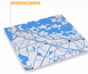 Places with similar names to Ấp Phước Khánh, Vietnam ::
// Apgahan (PH)
// Ấp Cả Hoản (VN)
// Ấp Khánh Hậu (VN)
// Ấp Khánh Hòa (VN)
// Ấp Khánh Hội (VN)
// Ấp Khương Hòa (VN)
// Ấp Phước Khánh (VN)
Disclaimer :: Information on this page comes without warranty of any kind |
||
|
Where is Ấp Phước Khánh? Elevation and coordinates ::
Latitude (lat): 10°54'0"N Longitude (lon): 105°5'0"E
Elevation (approx.): 4m (map arrows pan, magnifying glasses zoom) |
||
|
Visiting Ấp Phước Khánh? Hotel/Accommodation ::
Book a hotel in Ấp Phước Khánh Travel Guide ::
Buy a travel guide for Vietnam rental cars ::
car rental offers GPS waypoint ::
download a GPX waypoint (PoI) of Ấp Phước Khánh for your GPS receiver
|
||