|
search place name
|
||
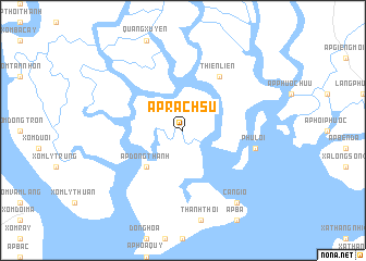
Ấp Rạch Sư (Hồ Chí Minh, Vietnam)Ấp Rạch Sư is a town in the Hồ Chí Minh region of Vietnam. An overview map of the region around Ấp Rạch Sư is displayed below.
regional and 3d topo map of Ấp Rạch Sư, Vietnam ::
Ấp Rạch Sư airports ::
The nearest airport is SGN - Ho Chi Minh City Tansonnhat Intl, located 47.1 km north west of Ấp Rạch Sư.
Nearby towns ::
Ấp Dồng Thành (5.2km south west) //
Thiền Liền (6.6km north east) //
Phú Lợi (7.5km east) //
Ấp Nhì (9.2km south east) //
Cần Giờ (9.2km south east) //
[all distances 'as the bird flies' and approximate] 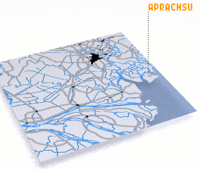 Places with similar names to Ấp Rạch Sư, Vietnam ::
// Ap Rạch Soi (VN)
Disclaimer :: Information on this page comes without warranty of any kind |
||
|
Where is Ấp Rạch Sư? Elevation and coordinates ::
Latitude (lat): 10°29'0"N Longitude (lon): 106°55'0"E
(map arrows pan, magnifying glasses zoom) |
||
|
Visiting Ấp Rạch Sư? Hotel/Accommodation ::
Book a hotel in Ấp Rạch Sư Travel Guide ::
Buy a travel guide for Vietnam rental cars ::
car rental offers GPS waypoint ::
download a GPX waypoint (PoI) of Ấp Rạch Sư for your GPS receiver
|
||